The starting point of the Ilek narrow-gauge railway was the village of Chus, located near the right bank of the Kama River. The starting point of the Perervinskaya narrow-gauge railway was the village of Kurya (most often indicated on topographic maps as Kamsky), located near the right bank of the Kama River, approximately 50 kilometers north of Chus. For a long time, narrow gauge railways worked as a single network.
According to information from P. Kashin, the first section of the narrow-gauge railway near the village of Kurya (Kamsky) was built in 1949. The narrow gauge railway belonged to the Perervinsky timber industry enterprise. Initially, it bore the official name “Skachkovo Narrow-Gauge Railway,” which originated from the neighboring village of Skachok. In 1960, it was given a different name - the Perervinskaya narrow-gauge railway.
The Ilek narrow-gauge railway (starting point is the village of Chus) was founded in a similar period of time. The owner of this narrow-gauge railway was the Kaysky timber industry enterprise.
Around 1960, the Ilek and Perervinskaya narrow gauge railways were connected. It became possible to travel by rail from Chus to Kurya, which improved living conditions in the remote village of Kurya, which had no road connections (there was a road in Chus at that time). A passenger train regularly ran on the Chus - Kurya route.
On the Perervinskaya narrow-gauge railway there was a forest village called Zhekan (evicted in 1975) and a significant number of rotational forest camps in which “lifters” lived - producers of resin (pine resin). Harvesting resin, along with logging, was widespread in this area.
According to P. Kashin, around 1975, the Ilek narrow-gauge railway, running from the village of Chus in an eastern direction, was dismantled. From that time on, only the Perervinskaya narrow-gauge railway (from the village of Kurya to the south) operated. The length of the highway was 22 kilometers, the rest was dismantled.
In the 1980s, the logging station in Kurye was gradually transferred to road haulage. After 1985, regular export of timber by narrow-gauge railway was stopped; from that time on, it was carried out only during times of mud, when the movement of timber trucks became problematic. In 1990, the last section of the narrow gauge railway was dismantled. One of the TU6A diesel locomotives was transported to the Khristoforovskaya narrow-gauge railway.
In August 2007, railway researchers P. Kashin and S. Kostygov visited Chus and Kurye. According to information from P. Kashin, in Kurye the cabin of the MD54-4 motor locomotive, lying on the bank of the Kama, was preserved. In Chusa, no rolling stock of the narrow-gauge railway has survived.
The Ozhmegovskaya narrow-gauge railway was a timber-carrying, “floating” railway, owned by the Kaysky timber industry enterprise. According to the records of the former Ministry of Forestry, the first section of the narrow gauge railway was opened in 1952.
The length of the narrow-gauge railway lines at the peak of its development was at least 70 kilometers. There were several rotational camps on the lines of the narrow-gauge railway (Knyazevka, Dalniy Kym and others). The villages were intended for the temporary residence of workers-rafters (procurers of resin).
The narrow gauge railway has been completely dismantled. The estimated eradication period is the 1970s.
__________________________________________________________________________________________________
This narrow-gauge railroad carried timber and was run by a correctional labor institution. The starting point of the narrow-gauge railway, the village of Sosnovka I, was connected by a broad-gauge branch to the Razdelnaya station of the Gayno-Kay railway.
The length of the narrow-gauge railway, according to topographic maps, was about 30 kilometers.
The narrow gauge railway has been completely dismantled. The estimated liquidation period is the early 1990s. Later, the village of Sosnovka I was liquidated, and the broad-gauge branch leading to it was dismantled.
__________________________________________________________________________________________________
__________________________________________________________________________________________________
As of 2008, the narrow gauge railway is operational.
__________________________________________________________________________________________________
Narrow gauge railway on a 1:100,000 scale topographic map published in 1962.
Narrow gauge railway on a 1:200,000 scale topographic map published in 1986.The Verkhnekamsk phosphate mine has been the main enterprise of the Verkhnekamsk region for a long time Kirov region. The mine mines phosphate rock using an open pit method.
According to information from railway researcher P. Kashin, the narrow-gauge railway at the Verkhnekamsk phosphorite mine was opened in 1915 - long before the appearance of the broad-gauge railway in the area. Presumably, at that time it led to a pier on the banks of the Kama River, from which phosphate rock was transported by water.
In the 1930s, a broad gauge railway line was opened from Yar station to the phosphate mine. From that time on, the mine's products began to be transported by rail. Near the village of Rudnichny, a multi-level intersection of broad and narrow gauge railway lines was built.
The narrow gauge railway reached its highest development in the early 1980s. At that time, its length was at least 40 kilometers.
In the 1980s, a decision was made to reconstruct the narrow-gauge railway to a standard 1520 mm gauge. According to information from P. Kashin, reconstruction work on a broad gauge was completed in 1987. Almost all diesel locomotives working on the narrow-gauge railway were cut down or transferred to other narrow-gauge railways.
As of 2003 (information from P. Kashin), the Verkhnekamsk phosphate mine was practically not working. On the broad gauge railway line belonging to the mine, there was one narrow gauge diesel locomotive adapted for operation on broad gauge tracks - TU7-1336, and a significant number of broad gauge diesel locomotives (TGM4, TGM40 and others).
As of May 2008, the Verkhnekamsk phosphate mine was almost idle. The broad gauge railway line belonging to the mine, leading to the quarries located southwest of the village of Rudnichny, was not in operation, but was not dismantled.
__________________________________________________________________________________________________
Narrow gauge railway in the vicinity of the village of Brusnichny. The starting point is the village of Brusnichny (does not exist since the 1970s).
Narrow gauge railway on a topographic map at a scale of 1:100,000,
published in 1962 (eastern part), 1967 (western part).
Marked only in the eastern part.
The only source of information about this narrow gauge railway is a 1:100,000 scale topographic map published in 1962. The narrow gauge railway was a timber railway. The length of the narrow-gauge railway, according to the map, was about 8 kilometers.
The narrow gauge railway has been completely dismantled. Estimated eradication period: 1960s.
__________________________________________________________________________________________________
Loevskaya (?) narrow gauge railway. The starting point is the village of Loevka (does not exist since the 1970s).
Narrow gauge railway on a 1:100,000 scale topographic map published in 1967.
The location of the narrow gauge railway on the topographic map
scale 1:200,000, published in 1986.The only source of information about this narrow gauge railway is a 1:100,000 scale topographic map published in 1967. The narrow-gauge railway was a timber-carrying, “floating” one. The length of the narrow-gauge railway, according to the map, was about 20 kilometers.
The narrow gauge railway has been completely dismantled. Estimated eradication period: 1970s. At the same time as the narrow-gauge railway, the village of Loevka was liquidated.


In 2012, the company launched its first own project in residential construction - the high-tech cottage community iLand. Each house is equipped not only with a “Smart Home” system, when everything (light, audio, video, security and climate control) can be controlled from one device and at a distance, but also in each apartment there is a comprehensive climate control system installed inside the house ( temperature, air conditioning, as well as air purification and humidity control).
Official Partner Diploma construction company"Iron"
After successfully commissioning the projects, the Zhelezno company set its sights on managing exclusively its own complex housing construction projects.
And the first was the construction project of the new Metrograd microdistrict in 2012.
In 2014, the first stage of apartments was commissioned and a new project was launched - the Yolki Park eco-complex, in which for the first time in Kirov the developer presented a new format of housing - these are luxury houses, duplex apartments, townhouses.
In 2016, construction began on an even larger-scale ZNAK residential complex.
In 2017, the Zhelezno company merged with the ATEX company and took control of another residential complex in the Raduzhny microdistrict - Vasilki.
New buildings from the developer "Zhelezno"
The company builds only from bricks. All houses are lined with Japanese energy-saving facades. The new houses of the residential complex are equipped with their own gas boiler room, which allows you to independently regulate the temperature in your apartment.
The developer offers apartments in both rough and finishing at very affordable prices, as well as various layout options.
The development company has firmly occupied its niche in the Kirov real estate market and is very popular among buyers.
Residential complex "Metrograd"
Residential complex low-rise buildings Metrograd donated 80,000 sq.m. to the South-Western district of Kirov. comfortable housing. Cozy streets, brick low-rise (3-5 floors) houses, playgrounds with safe surfaces, and the availability of everything necessary for life within walking distance create a decent picture for living.
Since the start of construction in 2013 of “city after city,” as it is called, Metrograd has received many grateful reviews from consumers for practical layouts (the area of residential premises has been increased by reducing utility rooms), economical prices, and ensuring the safety of residents of the microdistrict.
Also, by 2017, it is planned to launch a city route inside the residential complex, build a hockey rink and lay kindergarten for 200 seats.
Residential complex "Elki-Park"
The innovative approach to construction and the leadership of the Palace of Culture Zhelezno can also be seen in the construction of the eco-village Elki-Park. The complex is located in an ecologically clean area (near the Arboretum and the bank of the Vyatka River). The residential complex accommodates apartment buildings, luxury houses and townhouses. The layout of the village will not allow cars to move along local area. There should be children's playgrounds and recreation areas. Parking is provided at the rear of the buildings. Air ventilation system and individual gas heating will reduce costs and provide comfortable living.
Residential complex "ZNAK"
The company's largest project, luxury houses. When designing this residential complex, the developer used “smart planning” technology - the construction of apartments according to the portrait of its future residents. And he made any type of apartment as comfortable as possible for life: these are studios with 2 windows, 2-room apartments with 2 bathrooms, “euro three-room apartments,” etc. In the ZNAK residential complex it is planned to build the most modern school Kirov per 1000 students.
Residential complex "Vasilki"
This is a modern and functional eco-park with low-rise buildings - three-story houses, townhouses and houses based on individual projects. The main advantage is the location near picturesque natural sites - a forest, an arboretum and the bank of the Vyatka River.
Test
discipline: "Transport hubs"
on the topic: “Transport hub of the city of Kirov”
Completed by: Kan A.V., 3rd year student, group GTB-11
Checked by: Kopylova O.A., assistant
Magnitogorsk, 2013
City of Kirov. 3
Transport. 4
1. Road network and automobile transport Kirov. 4
2. Kirov public transport. 6
3. Kirov railway transport. 6
4.Air transport of Kirov. 8
Kirov city
Kirov is a major transport hub. The Kirov Railway existed from 1914 to 1959 (until January 21, 1935 it was called the Murmansk Railway). Near the city there is the federal highway A119 “Vyatka”, connected to the Kirov entrance. By 2011, it is planned to complete the construction of the federal highway “St. Petersburg - Yekaterinburg” on the section “Kostroma - Kirov - Perm”.
The regional highway P159 connects Kirov with Nizhny Novgorod. Regional highways P166 “Kirov - Slobodskoy - Belaya Kholunitsa” begin in the city,
P167 “Kirov - Tsepeli - Swifts”, P168 “Kirov - Adyshevo -
Nizhneivkino", R169 "Kirov - Malmyzh - Vyatskie Polyany". Construction of the regional highway "Kirov - Kotlas - Arkhangelsk" is underway.
The Northern (from Yaroslavl) and New (from Nizhny Novgorod) passages of the Trans-Siberian Railway pass through Kirov.
Transport
Road network and road transport of Kirov
The city has a developed transport infrastructure. The total length of the road network in Kirov is 562 km, of which 90 km are city-wide main streets, 58 km are district streets. The city has 3 multi-level interchanges, 30 bridges and overpasses, including 2 bridges over Vyatka - Old and New.
In the main city limits, streets are numbered along parallels from Vyatka to the west, along meridians - from north to south. The major main streets are Oktyabrsky Avenue and Stroiteley Avenue, Lenin, Karl Marx, Ivan Popov, Luganskaya and Proizvodstvennaya streets in the north-south direction and Dzerzhinsky, Lepse, Profsoyuznaya, Moskovskaya, Drelevsky, Vorovsky, Nekrasov, Komsomolskaya and Shchorsa streets in the east-west direction.
The provision of the population with individual passenger cars is 250 cars per 1000 people. There are 45 thousand individual garages in the city, which is 46% of the required number.
Transport corridor: the road starts from the federal highway R-176 “Vyatka” near the city of Muroshi, will pass through the Kirov region along the Kirov-Kotlas railway line and further to Arkhangelsk.
Figure 1. Map highways Kirov
Public transport in Kirov
Public transport in Kirov is represented by buses, trolleybuses and minibuses.
The total length of the passenger route network in Kirov in 2007 was 816 km, including bus routes - 695 km, trolleybus routes - 92 km, minibus routes - 58 km. Total number Vehicle is 696 units, of which 545 buses, 120 trolleybuses and 39 route taxis. There is a tendency to replace small-capacity buses (PAZ brand) with large buses (LiAZs and NefAZs of new modifications). In 2008, public transport carried out 1.411 million trips, carrying more than 121.6 million passengers in total. All buses are equipped with a GPS monitoring system.
Suburban communication is carried out through the bus station, as well as the suburban terminals of the Kirov railway station and the Kirov-Kotlas station.
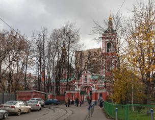
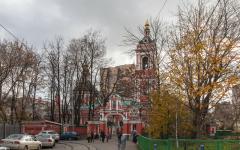
Railway transport of Kirov
Kirov is the center of the Kirov branch of the Gorky Railway. There are 8 railway stations in the city, three stations have railway stations, the largest of which is the Kirov station, built in 1902. It serves passenger trains traveling along the Trans-Siberian Railway, as well as commuter trains. From the station, branded train No. 31/32 “Vyatka” departs, as well as passenger trains going to Kazan, Nizhny Novgorod, Kotlas, and in the summer - to Adler, Anapa, Simferopol.
The railway station of the Kirov-Kotlas station (formerly the Vyatka station), built in 1897, serves trains of the Kotlas (northern) direction. The Lyangasovo railway station serves the Lyangasovo microdistrict, which is an enclave of the city within the municipality. The total length of the double-track electrified railway within the city of Kirov is 60 km.
Main directions:
From Murmansk to Volkhovstroy (meridional), the section from Volkhovtsroy station to Tikhvin connects St. Petersburg with the Northern Railway and, through it, with Arkhangelsk and with exits to the Urals and Siberia. The Kirov Railway also includes the Petrazovodsk-Suoyarvi line, built during the fight against the Bellofins in the shortest possible time and in the most difficult conditions. From Suoyarvi the road lines go further to Serdobol. Kirov Railway cuts Kola Peninsula, serving the Murmansk region, the Karelo-Finnish SSR and minor parts of the Leningrad and Vologda regions.

Figure 2- Map of the railway city of Kirov
Construction of the Murmansk railway. Beginning of the 20th century
From ICCM funds
MURMANSK RAILWAY, (Kirov Railway since 1935, Murmansk Branch of Oktyabrskaya Railway since 1959), railway line from Murmansk to St. Petersburg 987 versts (1044 km). The issue of its construction was first considered in 1894 by a commission headed by comrade (deputy) Minister of Railways, Lieutenant General Petrov. Arkhangelsk Governor A.P. Engelhardt was an active supporter of its construction. Funds for preparatory work stood out already in 1903–1904, but the outbreak of Russo-Japanese War. The final decision on construction was made on 01/01/1915. Survey work was completed in 3 months. Construction began in March 1915, on the northern section - in early June. They built the road recruited from middle zone Russian peasants and Chinese from the Far East, as well as prisoners of war of the First World War (thousands of Hungarians, Germans, Slovaks, Czechs). A total of about 70 thousand people were employed. (according to other data - up to 100 thousand people). Many traveled due to the lack of roads through Finland, Norway and Sweden, for this Scandinavian countries provided special transit trains. Construction was carried out in 3 sections simultaneously: Petrozavodsk–Soroka, Soroka–Kandalaksha, Kandalaksha–Murmansk. The mountainous and swampy terrain complicated the work. About 1,100 bridges were built from Petrozavodsk to Murmansk alone. The laying of rails began in August 1915. The village near Semenovskaya Bay of the Kola Bay was chosen as the final station. On April 23, 1916, the northern section of the road, Kandalaksha–Murmansk, opened, and through traffic began on November 3, 1916. On this day, after performing a prayer service around settlement Poyakonda was hammered into the last spike at the junction of the continuous rail track Petrozavodsk-Romanov-on-Murman. This was done by Major General Prince Bagration-Mukhransky, specially sent by Emperor Nicholas II. The construction manager, engineer Goryachkovsky, sent a telegram to the Emperor: “We are happy to please you, Sovereign, and Russia that this November 3 at 12 noon, at 537 versts from Petrozavodsk, I closed the line of the Great Northern Route, leading Russia to the primordially Russian lands, to the expanse of the free ocean... »
The construction of the road was planned to cost 180 million gold rubles, but actually amounted to 350 million. But the country gained access to ice-free all year round seaport and, without knowing it then, to huge reserves of minerals. By the decision of the Provisional Government on April 18, 1917, the Olonets Railway was attached to the Murmansk Road. By the fall of 1917, the road did not have even 25% of its designed capacity. During Civil War about 80% of steam locomotives, 60% of carriages and a significant part of the railway track. d. were destroyed. 06/02/1920 V.I. Lenin signed a resolution of the Council of Labor and Defense on the operation and completion of the railway. 05/25/1923 STO announced the colonization and economic development of the Kola region, which was entrusted to the railway (Colonization of the Karelo-Murmansk region).
Road management in different time was located in Petrozavodsk, Petrograd, Belomorsk. The station in Murmansk was opened on March 23, 1923. Trains from the North to Leningrad began running in the summer of 1924. Everything lost was restored by the end of the 1920s. In 1929 they began to build a railway line to the future city of Kirovsk.
By order of the People's Commissariat of Railways dated January 27, 1935, the Murmansk Railway was renamed the Kirov Railway.
The road was badly damaged in 1941–1944. German aviation carried out 2,800 raids on it. More than 90 thousand bombs were dropped. 1,126 railway buildings and structures were destroyed, over 500 locomotives and 4,950 carriages were damaged. But the road was in operation throughout the years of the Second World War (due to the capture of Petrozavodsk and the section of the route from Maselga to Svir by Finnish troops, trains ran along the specially urgently built Sorokskaya-Obozerskaya road). 1,246 thousand tons of military equipment and military materials, equipment and food received from the allies under Lend-Lease were sent from Murmansk to the interior of the country.
In the 1950s. The Murmashi-Nickel railway line came into operation, and then to the village. Revda, Kovdor. There are no railway access roads to 2 regional centers - the village. Lovozero and village Umba.
In 1959, the Kirov Railway was annexed to the Oktyabrskaya Railway (Murmansk branch).
In the 1990s. 8 stations are closed, including Kilpyavr, Pechenga, Safonovo, etc. The Murmansk–Vaenga, Pyaive–Kilpyavr, and Ruchi Karelskie–Alakurtti sections ceased operations.
Lit.: Murmansk Railway. A brief outline of the construction of the railway in Murman with a description of its area. - Petrograd, 1916; Surozhsky P. How the Murmansk Railway was built // Chronicle. 1917. No. 7–8; Griner D. A. From the history of Murman and the Murmansk railway // Chronicle of the North. - M.‑L., 1949. T. 1; Kharitonov S.V. A story about the great northern route. - Petrozavodsk, 1984; Khabarov V. A. Highway. - Murmansk, 1986; Yudkov S. Across the tundra, by rail // Murmansk Bulletin. 2012. September 22.
The Gorky Railway serves the Middle Volga region and the Urals. Connects the central and northwestern regions of Russia with the Urals, opening access to Siberia and Far East. Mainly served by Privolzhsky federal district, but several hundred kilometers of its lines run through the neighboring Central and Ural districts, there is one station in the North-Western.
In total, the service area of the Gorky Railway includes 15 regions of Russia, among which 6 republics:
- The Republic of Mordovia;
- Chuvash Republic;
- Udmurt republic;
- Republic of Tatarstan;
- Mari El Republic;
- Republic of Bashkortostan.
AND 8 areas:
- Moscow;
- Vladimirskaya;
- Nizhny Novgorod;
- Kirovskaya;
- Sverdlovskaya;
- Vologda;
- Ryazan;
- Ulyanovskaya;
- Perm region.
Nizhny Novgorod Region- 77 thousand sq. km. territory and 3.5 million inhabitants.
IN Nizhny Novgorod located the biggest There is a railway station on the Gorky railway.
Near the center of the region there is a road leader in loading (Zeletsino station).
Importantshipper region - OJSC "Vyksa Metallurgical Plant"- the world's largest manufacturer of wheels for rail transport.
At the station Nizhny Novgorod - Sorting Up to 70 trains are being formed.
Mari El Republic - 23 thousand sq. km. and 750 thousand inhabitants. Construction materials, timber, glass, and petroleum products are sent from the republic.
Chuvash Republic - 18 thousand sq. km. and 1.35 million inhabitants. Chemical, foundry, machine-building production, carriage building and car repair receive products and raw materials by rail.
Kirov region- 120 thousand sq. km. and 1.5 million inhabitants. The railway station, which is located in the center of Kirov, is one of the top three on the road in terms of the number of passengers sent. A large marshalling station is Lyangasovo.
Udmurt republic- 42 thousand sq. km. and 1.6 million inhabitants. Many enterprises located in Izhevsk, Glazov, Sarapul send and receive dozens of wagons with cargo every day.
Vladimir region- the road lines run through the center, southern and eastern parts of the region. The stations are located in the largest cities: Vladimir, Kovrov, Murom, Gus-Khrustalny. Enterprises in the construction industry, glass industry and mechanical engineering receive their products by rail.
Republic of Tatarstan- 67.8 thousand sq. km. and 1.1 million inhabitants. Two large marshalling yards- Agryz and Yudino. GZhD works with enterprises of the city of Zelenodolsk, with producers of agricultural products.
Currently, the highway includes 5 regional centers:
- Muromsky;
- Gorkovsky;
- Kirovsky;
- Kazansky;
- Izhevsky.
Main routes of the highway- these are two parallel latitudinal directions connected to each other:
Moscow - Nizhny Novgorod - Kirov;
Moscow - Kazan - Ekaterinburg.
The main tracks of the road are equipped mainly with heavy R-65 type rails.
The neutral section of the Trans-Siberian Railway runs along the State Railway, hence its great transit importance. However, the area of responsibility of the State Railway is also the territory of significant initial shipment of goods, including oil and its products, products of chemical enterprises and enterprises producing agricultural fertilizers, enterprises metallurgical complex and mechanical engineering, enterprises for the procurement and processing of forest products, construction materials.
Use the services of the road 205 administrative-territorial districts where he lives more than 14 million people. Passing through the territories where the largest number of Russian million-plus cities are concentrated, The State Railway is one of the roads with the highest passenger traffic.
On the Gorky Railway operates 373 stations. Higher 250 stations carry out cargo operations. Large marshalling stations of the Russian Railways network are Nizhny Novgorod-Sortirovochny, Lyangasovo, Agryz, Yudino.
GZD- one of the most technically equipped roads Russian Federation. Specific gravity electric traction in transportation is about 90 percent.
The operational length of the road is 5,331.4 km.
The total deployed length of the tracks is 11,873.2 km.
The total length of the access roads is 677.84 km.
The expanded length of the station tracks is 3,129.98 km.
The total length of electrified tracks is 7,318.1 km.
74 cities stand on the civil railway lines, in close proximity to them or on access roads leading to its stations.
The total length of the main railway tracks is 7,959.4 km(this is comparable to the total length of the railway network in Hungary).
The area of the territory served by the Gorky Railway is 390,000 m2(this is larger than, for example, Japan, Germany or Finland).
GZD- This clear example how the unique experience of the oldest representatives of the industry is skillfully complemented by new technologies and modern approaches to business process management.
Gorkovskaya- the only railway in the world that bears the name of the writer. But it is also true that it is named after a railroad worker. After all, Maxim Gorky wrote his first published story “Makar Chudra” in the summer of 1892, while working in the workshops of the Transcaucasian Railways in Tiflis. By the way, one of the most beloved passenger branded trains - "Burevestnik" - also received its name in memory of the writer.
A new page in the history of the highway was opened by the high-speed traffic project on the line Nizhny Novgorod - Moscow - St. Petersburg. Before the launch of the high-speed train project, train running times ranged from 5 hours 20 minutes to 8 hours. Today it amounts to 3 hours 35 min.
April 28, 2013 The Lastochka high-speed electric train was launched on the Gorky Mainline, covering the distance from Moscow to Nizhny Novgorod in 4 hours.
June 1, 2015 At the Kursky railway station in Moscow, a solemn event was held dedicated to the departure of the new high-speed electric train Talgo 250 under the brand name for the first flight with passengers "Swift" on the route Moscow - Nizhny Novgorod. The Strizh train Moscow - Nizhny Novgorod is capable of transporting over 400 passengers. The train includes carriages with 1st and 2nd class seating, SV (VIP) carriages, a buffet car and a restaurant car. All carriages are equipped with air conditioning systems and environmentally friendly toilet facilities. Travel time is 3 hours 35 minutes.
August 3, 2014, On the first Sunday of August - the day when Russian railway workers traditionally celebrate their professional holiday - the Museum of the History and Development of the Gorky Railway opened.
Main goals Gorky Railway - timely and high-quality provision, in interaction with other organizations, of the needs of the state, legal and individuals in railway transportation, related works and services, provision of services to users of the railway transport infrastructure.
Gorky road borders with railways:
- Moskovskaya (Petushki and Cherusti villages);
- Sverdlovskaya (st. Cheptsa, Druzhinino);
- Northern (st. Novki, Susolovka, Svecha);
- Kuibyshevskaya (st. Krasny Uzel, Tsilna, Alnashi).