Vladimir Averyanov
The existence of a highly developed civilization in Antarctica began to attract the attention of professional historians after World War II. The hypothesis is confirmed by medieval maps and studies by Western paleogeologists and glaciologists.
In January 1820, Lieutenant of the Russian Imperial Navy Mikhail Petrovich Lazarev discovered a new continent on the then map of our planet. Famous Russian encyclopedic Dictionary Brockhaus and Efron already at the beginning of this century reported that the south polar continent was poorly studied; flora and fauna are absent, indicating a rough estimate of the area of the continent. The author of the article also noted the richness of Antarctic waters in algae and marine animals.
A little over twenty years later, the director of the National Museum in Istanbul, Khalil Edhem, was sorting out the library of the Byzantine emperors in the old palace of the sultans. Here, on a dusty shelf, he discovered a map that had been lying around since God knows when, made on the skin of a gazelle and rolled into a tube. The compiler depicted on it the western coast of Africa, the southern coast of South America and the northern coast of Antarctica. Khalil couldn't believe his eyes. The coastal edge of Dronning Maud Land south of the 70th parallel was free of ice. The compiler marked a mountain range in this place. The name of the compiler was well known to Edhem - admiral of the Ottoman Empire navy and cartographer Piri Reis, who lived in the first half of the 16th century.
The authenticity of the card was not in doubt. A graphological examination of the notes in the margins confirmed that they were written in the admiral’s hand.
1949 A joint British-Swedish research expedition carried out intensive seismic exploration of the southernmost continent through the thickness of the ice sheet. According to the commander of the 8th Technical Intelligence Squadron of the US Air Force Strategic Command (07/06/1960), Lieutenant Colonel Harold Z. Ohlmeyer, “the geographical details depicted in the lower part of the map (the coast of Antarctica - V.A.) are in excellent agreement with seismic data... We We have no idea how to reconcile the data on this map with the supposed level of geographical science in 1513.”
Piri Reis himself, in marginal notes compiled at the beginning of the 16th century, very kindly explained to us that he himself was not responsible for the primary survey and cartography, and his map was based on large quantities earlier sources. Some of them were drawn by his contemporaries (for example, Christopher Columbus), others date back to more ancient times and can be dated back to the 4th century of the pre-Christian era. Not later, since one of the sources belonged to Alexander the Great, who lived in that era.
Of course, professional historians specializing in the study of the ancient world have the right to say: “Another working hypothesis... But what about documentary sources and preferably those that do not raise doubts about their ancient origin? The opinion of the Turkish admiral. Notes in the margins, this, you know, is all very controversial.”
I will present the position, unfortunately, of the now deceased historian of science, professor at Kean College (New Hampshire, USA), Charles H. Hapgood. Back in late 1959, in the Library of Congress in Washington, Hapgood discovered a map compiled by Orontheus Finius. The dating of the drawing is the year 1531 from the Nativity of Christ. Oronteus Finius depicted Antarctica with ice-free shores, mountains and rivers. The relief of the central part of the continent is not marked, which, according to Hapgood, suggested the presence of an ice cap in this area.
A later study of the Finius map by MIT doctor Richard Strachan in the first half of the 60s, together with C.H. Hapgood made it possible to establish that O. Finius actually depicted the ice-free shores of Antarctica. General outline and characteristics relief are very close to the information about the surface of the continent hidden under the ice, which was mapped in 1958 by specialists from different countries(including from the USSR). By the way, Gerard Kremer, known throughout the world under the name of Mercator, also trusted the testimony of Oronteus. In 1959, he included the Finius map in his atlas, which contains several maps of Antarctica and Mercator himself. Moreover, there is one interesting feature- Mercator's map, drawn up in 1569, depicts the western coast of South America less accurately than Mercator's earlier map of 1538. The reasons for this contradiction are as follows: when working on an early map, the 16th century cartographer was based on ancient sources that have not reached us, and when working on a later map, on the observations and measurements of the first Spanish explorers of western South America. Gerard Mercator's mistake is excusable. In the 16th century, there were no precise methods for measuring longitude and, as a rule, the error was hundreds of kilometers, i.e. from 20 and more.
And finally, Philippe Boishet. Full member of the French Academy of Sciences. In 1737 he published his map of Antarctica. Buache gave an accurate picture of the time when Antarctica was completely ice-free. His map shows the subglacial topography of the entire continent, which our humanity, which considers the origin of its civilization no earlier than the 4th millennium BC, did not have a complete understanding of until 1958. Moreover, based on now lost sources, the French academic depicted a body of water in the middle of the southernmost continent, dividing it into two subcontinents lying to the west and east of the line where the Transantarctic Mountains are now shown. Research under the International Geophysical Year program (1958) argues that the southernmost continent, which is depicted as a single continent on modern maps, is in fact an archipelago of large islands covered with ice at least 1.5 km thick.
Let's summarize the first results:
A. Medieval maps show Antarctica without ice cover or retaining partial ice cover. The accuracy of cartographic estimates of the 16th century is very high and surprising in a number of ways. Their data is superior technical capabilities even the late Middle Ages (for example, determining the longitude of the currently subglacial relief with an accuracy of up to a minute). In the very best case scenario This level of engineering of our humanity corresponds to the last quarter of the 18th century, and for many issues (data on subglacial relief) - only to the middle of this century.
B. The interpretations of Medeevist historians (specialists in medieval history) about the geographical maps of Reis, Finius and Mercator for Antarctica cannot be considered convincing. The Medeevists refuse to comment on such a high scientific level of medieval cartographers. Information about the almost two-thousand-year-old original sources of the P. Reis map is considered to be undocumented. The opinion of modern cartographers, based on strictly scientific assessments in the field of natural science, is considered to be incompetent.
B. Orthodox geology agrees with this formulation of the question, arguing that the age of Antarctic ice can be estimated at no less than 25 million years. True, in last years this chronological frame has decreased to 6 million. But such an adjustment has already acquired a strict academic character.
In this case, we note the following feature of the Reis map: the coastal edge of the continent is free of ice. On the Finius map, compiled 18 years after the Reis map, the ice cap around the South Pole is preserved within the 80th, and in some places 75th, parallels. Academician Buache 200 years later depicted Antarctica without ice.
The conclusion, I believe, suggests itself. We are faced with the process of glaciation of the surface of the southernmost continent.
In 1949, Admiral Byrd's expedition drilled the bottom of the Ross Sea approximately in the places where Oronteus Finius indicated the river beds. The core sections revealed layers of fine-grained rocks, well-mixed sediments brought to the sea by rivers whose sources are located in temperate latitudes (i.e., ice-free).
Using the radioactive dating method developed by Dr. W.D. Ury, scientists at the Carnegie Institution in Washington were able to establish with reasonable accuracy that the Antarctic rivers that were the sources of these fine sediments flowed, as shown on the Finius map, approximately 6,000 years ago. Only after this date, around 4000 BC, “glacial-type sediments began to accumulate at the bottom of the Ross Sea... Cores indicate that this was preceded by a long warm period.”
Thus, the maps of Reis, Finius, and Mercator give us an idea of Antarctica around the time of the birth of the Egyptian and Sumerian civilizations. Such a point of view is excluded by almost all professional historians of the planet. My conclusion, at best, will be considered a working hypothesis, not amenable to historical verification. “Such civilizations on our planet at the end of the 5th millennium BC. did not exist,” any specialist historian will say. And the opinion of Dr. Jacob Hoke of the University of Illinois, that the sediments of a fluvial nature are between 6 and 12 thousand years old, counting from the present time, will be sent for discussion with paleontologists or paleobiologists, whose activities again go beyond the scope of the science of “History” and cannot contribute direct study of our highly developed and unique civilization.
But in September 1991, thirteen kilometers from the Nile in Abydos, American and Egyptian archaeologists discovered 12 large wooden boats, belonging to the pharaohs of the 1st Dynasty. The age of these vessels is estimated at approximately 5,000 years. They are considered one of the most ancient ships in the world, believes D. O'Connor, leader of the expedition, researcher at the University of Pennsylvania. While the find is being assessed traditionally, the boats were intended for religious ceremonies. Herodotus back in the 5th century. BC claimed that the Egyptians had been observing stars for more than 10 thousand years. This position is considered by the “father of history” to be esoteric, that is, secret, private, and because of this - untrue. But land-dwelling nations rarely produce astronomers. Perhaps the ancient Egyptians’ passion for astronomy is evidence of some kind of scientific heritage from a seafaring people unknown to us? By the way, technical intelligence officers of the US Air Force determined the center of the projection of the Piri Reis map, the data of which dates back to 4000 BC. Presumably the center was located near today's Cairo. At this time, according to the vast majority of historians, all the then peoples of the world were at an extremely primitive level of development.
The second result:
A. Between the fifth and tenth millennia BC. On planet Earth there was a civilization of people that had high knowledge in the field of navigation, cartography, and astronomy - no lower than the level of the last third of the 18th century.
B. This civilization preceded ours, and was not at all an alien product. The duration of its development can also count, like our civilization, several millennia. The location is presumably the northern coast of the southernmost continent, or archipelago of large islands - Antarctica, which was then in a temperate climate. In later years - the northeast of the African continent.
B. The reasons for the disappearance of civilization are the process of glaciation of the southern land, which began no earlier than the 10th millennium BC. We cannot exclude large-scale floods, quite stable, leading to long-term local floods, the presence of which archaeologists do not deny. Such disasters could destroy the vast majority of the material culture complexes of the protocivilization. It is quite possible that part of it is under the thickness of Antarctic ice. But as a serious working hypothesis, the position can already be accepted that the surviving representatives of the proto-civilization of the southerners retained and passed on part of their knowledge to the ancient Egyptians. Presumably, parallel to the Sumerians.
I hope that expanding the scope of archaeological research together with natural scientists will lead us to the southernmost continent. It is quite possible that surprises await humanity here.
The prehistoric era is defined as the period of human civilization that preceded the appearance of the first written evidence (before the 4th century BC), and initial stages ancient history are characterized precisely by written evidence of events. Our concept of ancient history is largely determined by the Bible. The absence of references to prehistoric cultures and civilizations, or the deliberate removal of such information from biblical texts, is the result of the rather isolated and limited approach of their authors to display historical events.
Amazing architectural monuments, man-made masterpieces and archaeological finds that go beyond our understanding, dating back centuries and millennia BC, present the history of human civilization in a completely different light. Since the destruction of libraries was a fairly common occurrence in ancient times, there are only a few sources of information left that could shed light on these secrets. Therefore, archaeologists and historians can only continue their painstaking work of studying forgotten civilizations.
1. Lens of Nimrud
The science of the ancient world, as modern research shows, was not as primitive and utilitarian as it is commonly imagined. The first samples of batteries and planispheres are not the only “gadgets” that have been discovered during archaeological research around the world. The most significant finds are considered to be the Nimrud lens and the Antikythera mechanism. The lens was discovered by archaeologists among the ruins of the Nimrud Palace in Iraq. Its age is determined to be approximately 3000 years. Some scientists believe that the lens was part of an ancient telescope that the Babylonians used to study celestial bodies and make high-precision astronomical calculations. The Antikythera Mechanism (200 BC) was used to calculate the motion parameters of celestial bodies to determine potential impact events. Unfortunately, it is impossible to say with 100% accuracy what exactly the purpose of these items was; It is also difficult to imagine why these inventions remained “behind the scenes” for several thousand years.
2. Empire of Rama

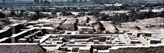
Despite wars and several major raids, the ancient history of India has felt the destructive influence of aggressors. It has long been believed that the history of Indian civilization dates back to 500 BC; however, some discoveries directly indicate that this date should be advanced by at least several thousand years. The ruins of the ancient cities of Harappa and Mohenjo-Daro were discovered in the Indus River Valley. The cities were such elaborate engineering complexes that archaeologists began to think seriously about how important their discovery had been. The origins and reason for the disappearance of the Harappan civilization also remain a mystery to specialists, and not a single linguist has been able to decipher the writing. By the way, during the excavations not a single religious building(for example, a temple or place of sacrifice); nor has any evidence been found for the class structure of Harappan society. This level of development is not found in any known human civilization (except for some common features with the ancient Egyptian and Mesopotamian cultures).
3. Longue Caves

The Chinese consider these caves to be the "ninth wonder of the ancient world" - the origin of the underground complex of 24 caves is still considered a mystery. Since its discovery by researchers in 1992, not a single documentary source or evidence has ever been conducted construction work was not found in this region - but to create the complex it was necessary to extract more than a million cubic meters stone! The hollowed-out stone corridors are also interesting because there is a repeatable pattern on the walls of the caves, which, according to scientists, has a symbolic meaning. This design is also found on pottery dating between 500 and 800 BC. BC.
4. Nan-Madol city

Nan Madol is a city that existed on the volcanic island of Pohnpei in Micronesia. It was built on a coral reef using huge (weighing up to 50 tons) basalt blocks and was a rather complex system united by numerous channels and tunnels. In terms of the complexity of its design and construction work, it is often compared to the Great Wall of China and the Great Pyramid (although the average weight of the blocks used to build the pyramid was no more than 3 tons). None of the existing sources found data about the construction period, purpose and, most importantly, the architects. Radiocarbon dating helped establish an approximate age of 200 BC. The origin of the basalt blocks also remains a mystery, as does the method of transport (50 feet high and 17 feet thick). In addition, the remains of the city's inhabitants indicate that they belonged to a race that has nothing in common with modern Micronesians.
5. Stone Age Tunnels
Across the territory from Scotland to Turkey, under the remains of hundreds of Neolithic settlements, archaeologists have discovered an extensive network of underground tunnels. Depths range from 2,300 feet (700 m) in Bavaria (Germany) to 1,200 feet (350 m) in Austria, which is a testament to the exceptional skill of the Neolithic builders, since most of the tunnels remain almost intact despite their considerable age - 12,000 years. Although not all tunnels have structural connections, experts believe that their main purpose was to provide people with the opportunity to safely move around the territory, regardless of the level of external danger. Also, special rooms were created in the tunnel system - in all likelihood, used as storage rooms and bunkers.6. Puma Punku
Puma Punku is one of the four structural components (complexes of buildings) of the ancient pre-Inca city of Tiwanaku in South America. The age of the megalithic complex is still the subject of lively debate, since the ruins were subjected to repeated “raids” by looters and amateur archaeologists - everything that could shed light on the mystery of Puma Punku was either destroyed or stolen. Scientists agree that the complex is much older Egyptian pyramids, hence, we're talking about about 15,000 years. Even the Incas didn't own sufficient quantity information about this object. On the massive stone blocks used to construct the buildings, there is not a single trace of contact with any construction tool; What is also striking is how precisely the blocks fit together. These data indicate high level mastery and knowledge of stone processing, engineering technology and geometry. The city also had an irrigation system, a water-protected sewer system, and a set of hydraulic mechanisms. Since scientists have never been able to discover any evidence informing us about the inhabitants of the city, the level of technological development remains one of the most intriguing mysteries.7. Metal clamps

Continuing the story of Puma Punku, we will talk about one intriguing detail - metal clamps used to connect large structures (monuments of the Incan culture of Qorikancha, Olantaytambo and Yurok Rumi, as well as ancient Egyptian temples). The grooves and holes found during the excavation of the walls, according to scientists, were used for transporting metal tools; but expert analysis showed that molten metal was poured into the excavations - therefore, builders had the opportunity to use portable smelters. In addition, melting the metals that were used during construction work required very high temperatures– as far as we know, such technologies were unknown to humanity at that time (at least, that was what was believed until recently). One can only guess why these technologies were forgotten over time (it is assumed that the civilization that replaced them simply ignored the knowledge and developments of the previous one).
8. City of Baalbek

The ancient Lebanese city of Baalbek is one of the best preserved monuments of ancient Roman culture in the world. Known as Heliopolis in ancient times, it amazes with its majesty and complexity. But scientists are much more concerned not with Heliopolis, but with the ruins of a megalithic complex discovered under the foundation of the city. The blocks found weigh at least 1,200 tons each - these are the largest hand-crafted stone structures in the world. Archaeologists date the ruins to the 9th millennium BC, since Middle (1900-1600 BC) and Early (2900-2300 BC) Bronze Age artifacts were discovered in the upper layers of the soil. It is impossible to explain how the material for construction was transported to this region from the mining site; Architects and engineers unanimously insist that during this period there were no technologies that could be used to lift huge stone blocks (among the arguments given are the location and limited space for using such mechanisms). However, none of the modern construction technologies can provide a clear answer to this question.
9. Giza Plateau

Hundreds of scientific works have been devoted to the mysteries of Ancient Egypt. Today it is no secret that the design of the Great Pyramid of Giza is a system the most accurate calculations(this raised doubts about the true purpose of the pyramid, which could have been more than just a tomb for burying the remains of the pharaoh). Moreover, since it has been proven that the destruction of the Great Sphinx statue was caused mainly by heavy rainfall (long rains were not uncommon in this area before the dry period began), the age of the pyramid is attributed to the 5th-7th millennium BC. (some scientists believe that the date should be “pushed back” a few thousand years ago). The sudden rise of Egyptian civilization in the 3rd millennium BC. became the reason for putting forward the hypothesis about the existence of more ancient culture, preceding the Egyptian one. It has also been established that such historical monuments as the Pyramid of Khafre, the Theban Necropolis and the Temple of Menkaure belong to this culture (limestone blocks were used in their construction - exactly the same ones were found in the foundation of the Sphinx).
10. Gobekli Tepe

Dating from the end of the planet's last ice age (1,200 years ago), a recently discovered temple complex in southeastern Turkey has been hailed as one of the most significant archaeological discoveries of our time. Examples of pottery, writing, prototype wheel and primitive metallurgical complexes are structures so advanced from a technological point of view that they “fall out” of the historical context of the Paleolithic era. Predating Stonehenge by thousands of years, the complex consists of 20 circular buildings (by this moment Only four have been excavated and studied) and intricately decorated pillars, 18 feet high and weighing approximately 15 tons each. It has not been established who designed and built the complex, and many questions remain about how a primitive hunter-gatherer civilization was able to excel in construction and the art of masonry.
Since the destruction of artifacts and written evidence, along with libraries and archives, was a fairly common occurrence in ancient times, there are only a few sources of information left that could shed light on these secrets. Therefore, archaeologists and historians can only continue their painstaking work of studying forgotten civilizations.
Humanity is already so old that it has forgotten its infancy, and the origin of man is shrouded in mystery. According to generally accepted views, humanity was primitive in the past, and then began to develop, people emerged from a state of barbarism, became smarter and more capable. New data, however, suggests otherwise. Maybe at the dawn of history humanity possessed highly developed science and technology, which significantly exceeds the ideas of modern people about the distant past. This point of view is as old as history itself. The ancients spoke of the past as an era of prosperity. The story of Atlantis in Plato's dialogue Timaeus is the most striking evidence of the Golden Age.
Medieval manuscript of Plato's Timaeus, Latin translation.
American Congressman Ignatius Loyola Donnelly (1831 - 1901) believed that Atlantis really existed, and collected all the available information about this ancient, powerful and advanced civilization. In 1929, a mysterious Piri Reis map from 1513 was found in Istanbul, showing the coasts of Antarctica and South America with modern accuracy. This map revived the hypothesis of advanced ancient civilizations, giving it solid ground. Archaeologist Brad Steiger, in his book Worlds Before Our Own, presented new facts about the existence of early developed civilizations. Steiger discovered that some high-tech artifacts were found in the lowest primordial geological layers, while primitive ones were found in the upper layers. He called them "irrelevant artifacts." His book contributed to a number of later works that challenged the prevailing view of humanity's past.  If advanced prehistoric civilizations existed, what led to their destruction? There are basically two possible scenarios: either these people were so advanced that they destroyed themselves, or they were destroyed by a natural disaster. The evidence in favor of the second option is more significant than the first. There are, however, some signs of ancient wars. World map of the Turkish admiral Piri Reis in 1513.
Creation and destruction“When the first atomic bomb exploded in New Mexico, the sand in the desert melted and turned into green glass. Archaeologists excavated in the ancient Euphrates Valley and discovered an 8,000-year-old layer of agricultural culture, then an even earlier layer, then a layer from the caveman era. Recently they have reached another layer - molten green glass." (New York Herald Tribune, 1947) Some scientists do not believe that ancient civilizations could have been destroyed by natural forces. They believe that the current features of the earth's surface were formed over millions of years. Dating using carbon dating cannot be considered absolutely accurate. This method assumes an established balance between the formation and decomposition of radioactive carbon in the earth's atmosphere. But the period of formation of C14 is actually longer than the period of its decay. Therefore, the amount of C14 in the atmosphere (0.0000765%) cannot be scientifically used as a criterion for dating fossils. In other words, we cannot know the age of the fossils from which we determine the age of the earth's strata. Thus, we do not know the actual age of the earth's strata. It is generally accepted that fossils of trees growing through several geological layers of the earth indicate that these layers belong to different historical eras. However, these layers could have been formed over a short period of time, for example, as a result of rapid sedimentation (deposition of layers) caused by a natural disaster, and not over millions of years, otherwise the emergence of petrified trees would simply not be possible. Myths and legends around the world speak of a global cataclysm, or more precisely, a flood. Similar myths can be found in Africa, China, North America, Australia, Sumer, in very distant cultures that had no way of contacting each other. There are more than 500 ancient legends about a flood similar to that mentioned in the Bible and Koran. These are traces of the global collective memory of an event that happened in the distant past.
If advanced prehistoric civilizations existed, what led to their destruction? There are basically two possible scenarios: either these people were so advanced that they destroyed themselves, or they were destroyed by a natural disaster. The evidence in favor of the second option is more significant than the first. There are, however, some signs of ancient wars. World map of the Turkish admiral Piri Reis in 1513.
Creation and destruction“When the first atomic bomb exploded in New Mexico, the sand in the desert melted and turned into green glass. Archaeologists excavated in the ancient Euphrates Valley and discovered an 8,000-year-old layer of agricultural culture, then an even earlier layer, then a layer from the caveman era. Recently they have reached another layer - molten green glass." (New York Herald Tribune, 1947) Some scientists do not believe that ancient civilizations could have been destroyed by natural forces. They believe that the current features of the earth's surface were formed over millions of years. Dating using carbon dating cannot be considered absolutely accurate. This method assumes an established balance between the formation and decomposition of radioactive carbon in the earth's atmosphere. But the period of formation of C14 is actually longer than the period of its decay. Therefore, the amount of C14 in the atmosphere (0.0000765%) cannot be scientifically used as a criterion for dating fossils. In other words, we cannot know the age of the fossils from which we determine the age of the earth's strata. Thus, we do not know the actual age of the earth's strata. It is generally accepted that fossils of trees growing through several geological layers of the earth indicate that these layers belong to different historical eras. However, these layers could have been formed over a short period of time, for example, as a result of rapid sedimentation (deposition of layers) caused by a natural disaster, and not over millions of years, otherwise the emergence of petrified trees would simply not be possible. Myths and legends around the world speak of a global cataclysm, or more precisely, a flood. Similar myths can be found in Africa, China, North America, Australia, Sumer, in very distant cultures that had no way of contacting each other. There are more than 500 ancient legends about a flood similar to that mentioned in the Bible and Koran. These are traces of the global collective memory of an event that happened in the distant past.
Flood myths exist in different cultures around the world.


As for its structure, engineers and scientists have concluded that it is impossible to build a pyramid of this size and with such stunning precision, despite modern technology. Engineer Markus Schulte estimates that the construction of the Great Pyramid would cost approximately $35 billion. Obviously, no one today would invest that kind of money in a colossal structure that is not suitable for habitation, and without any expected profit. Then the question is “how was it built?” is less important than the question “why was it built?”
Historians will probably never come to a common opinion about what the most ancient civilization in the world was. Official sources are repeatedly disputed by various legends of ancient peoples. The legends of ancient India and the Middle East say that the most ancient civilizations on Earth arose long before the appearance of the ancient peoples of Mesopotamia. And the ancient peoples already known to us simply used the knowledge of their distant ancestors.
There has been debate for centuries about which is the most ancient civilization on Earth, and history cannot yet give an exact answer to this question. The most ancient civilizations were the Hyperboreans, Atlanteans and the peoples of South Asia, which are known only from vague legends and traditions.
Atlanta
If a list were compiled that included the most ancient civilizations of the world, Atlantis would definitely be on it. This strange civilization existed, according to various sources, from 7 to 14 thousand years ago. Atlantis was first mentioned by Plato in his Dialogues. This ancient researcher learned about the existence of Atlantis from the elder Solon, who, in turn, relied on the knowledge of the Egyptian sages.

According to Plato, the Atlanteans lived on an island located in the Atlantic Ocean. This ancient civilization possessed enormous knowledge and possessed magnificent weapons. The Atlanteans themselves were distinguished by their great growth and longevity. But one night the Atlantean state sank into the sea, and not a trace remained of this ancient civilization.

Hyperboreans
A legendary country located in the far North. Very little is known about its origin - it is practically not mentioned in ancient Greek sources. But the Greeks knew that in a distant country the sun shines for six months, and night falls for six months. There are no bad winds in this country, but there are numerous meadows and groves. The Hyperboreans are glorious sailors and excellent traders. The Hyperborean civilization collapsed during the last Ice Age, when the entire territory of the forgotten country was covered with ice and covered with snow. The Hyperboreans gradually moved south and mixed with other peoples.

Until reliable scientific evidence of the existence of these peoples is obtained, the answer to the question of which civilization is the most ancient will be considered open. But both official and unofficial sources agree that most of the information that has survived to this day is about the Sumerian civilization.
Sumerian civilization
Reliable historical sources tell us that the most ancient civilization on Earth arose between the Tigris and Euphrates a little over 5 thousand years ago in the territory that modern historians call Mesopotamia. The Sumerians attributed their origin to the mysterious heavenly people - the Anunnaki, who descended to Earth in time immemorial. Perhaps these legends had some basis, otherwise it is difficult to explain why the people that emerged from oblivion suddenly began to rise sharply among the semi-wild primitive tribes. What was unique about the Sumerians and how did they achieve such an amazing breakthrough?
Social component
It is amazing how quickly the Sumerians built cities and fortresses of stone on the untouched lands of Mesopotamia. Moreover, the quality of the erected temples and buildings was so great that some fragments of the buildings that this ancient civilization erected have survived to this day.

In a short time, the Sumerians built an excellent administrative system that divided the state into cities and provinces, created an administrative apparatus and developed an established system of taxes and fees. Only many centuries later did the Egyptians recreate (or perhaps adopt from the Sumerians) a system for irrigating fertile fields and meadows. The Sumerians had an army, internal police, and courts - in general, all the attributes of a normal state system. How they managed to do this still remains a mystery.
Sumerian religion
The Sumerians worshiped not just one god, but an entire pantheon. All divine essences were divided into creative and non-creative. The creative gods were responsible for the birth and death of people, animals, light and darkness. The uncreative gods were responsible for order and justice. Interestingly, there was also a place for goddesses in the pantheon. Thus, the significant role of women in Sumerian culture was indirectly determined.

Scientific knowledge
Disputes about which civilization is the most ancient on the planet make no sense if one does not include in the discussion assessments of the level of scientific knowledge of one or another ancient people. Judging by scientific knowledge, the Sumerians were far ahead of all existing peoples at that time. They had considerable knowledge in the field of mathematics: they used the sexagesimal notation system, knew about the number “zero” and the Fibonacci sequence. Representatives of this ancient civilization knew how to calculate time from the stars and had considerable scientific knowledge in the field of natural sciences.
Astronomy and origins
The Sumerians knew about the structure solar system, and the Sun was placed at its center, not the Earth. The Berlin Museum houses a stone slab on which the Sumerians depicted the Sun surrounded by planets and objects in our system. These objects were not visible to the naked eye, and were only rediscovered by Europeans several thousand years later. It is interesting that this very ancient civilization knew about the wandering planet Nibiru. The Sumerians placed it between Mars and Jupiter and attributed it to a very elongated ellipsoidal orbit. It was the inhabitants of Nibiru, the mysterious Anunnaki, that the Sumerians considered their ancestors. According to the ancient legends of the Sumerians, all the knowledge they possessed was received by them from heaven.

The fall of the Sumerian civilization is rather associated with the assimilation of the “children of heaven” with various neighboring tribes. Based on historical facts, it can be assumed that the Sumerians mixed with other peoples and laid the foundation for successful and aggressive new states - Elam, Babylon, Lydia. Scientific knowledge and cultural heritage were preserved only to a small extent - most of the achievements of the Sumerians were lost in the fire of wars and forgotten forever.
At this point, the list, which includes the most ancient civilizations on Earth, can be considered closed. The civilizations of Ancient India and China appeared already during the heyday of Assyria, Elam and Babylon, which arose from the ruins of Sumerian culture. And the first Egyptian kingdoms arose even later. The most ancient civilizations on Earth left many scientific discoveries and developments that their contemporaries were unable or unwilling to take advantage of.
According to the theory of the origin of life on Earth, man is the first intelligent being born through the course of evolutionary development. We are so accustomed to thinking - and this is what academic science tells us - that we are the first on Earth who have intelligence. Before us, there were no civilizations with advanced technologies on the planet, although not all scientists agree with this opinion.
Many researchers believe that numerous incredible archaeological finds tell us that thousands and even millions of years ago there were already civilizations on Earth with extremely advanced technologies. Moreover, ancient civilizations may have had far superior knowledge and technology than we have today!
Studying ancient artifacts, scientists ask the question: What if all modern inventions of mankind are nothing more than a reproduction of the inventions of the past? That is, inventions from the time when different civilizations (possibly the colonization of the Earth came from deep space) inhabited the planet and then, without the support of the mother planet, the colonies degenerated and went wild, or the colonies were simply abandoned for some reason.
In fact, this is a very interesting hypothesis, however, under its basis there is a large pile of mysteries. After all, we will have to think about what could have caused development to be put on pause and even send highly developed civilizations of the past into the Stone Age. Meanwhile, most finds from ancient times are at least unexpected, and make you wonder where they came from.
What if, in our distant past, someone so powerful could have appeared that through his actions (for example, total bombing) he caused a “reset” in the evolution of growing civilizations? And from those developed civilizations that plunged into the “Stone Age” only archaeological finds remain, which we cannot explain, believing that we are the first on Earth.
Is it possible that some civilization from the distant past experienced a “reset”?
Could the existence of prehistoric civilizations explain the construction of incredible ancient monuments such as Puma Punku, Tiahuanaco, Teotihuacan and the Great Sphinx? Is it possible that our ancestors only discovered lost technologies and used them in their own lives, thereby beginning to revive the development that had once stopped?Let's look at some of the revolutionary technologies of ancient civilizations that still pose a mystery to researchers. Looking at individual artifacts, there seems to be nothing incredible about them, but looking at them together...
Ancient Chinese seismograph - seismoscope.
Even 1500 years before the invention of the modern seismograph, the Chinese scientist Zhang Heng (100th century AD) was able to record an earthquake. The invention is called a seismoscope - a device incredibly amazing in its beauty and precision (an elegant vase with carved bronze animals).

To this day, no one knows exactly how the amazing device worked, but, nevertheless, it worked! By the way, the scientist was the first to confidently declare that the Moon shines with reflected light.
Nuclear reactor of an ancient civilization 1.8 billion years old.
Many of us remember the discovery of a nuclear reactor in Africa about 1.8 billion years old. Traditional science explains that in fact this is a nuclear reactor built by nature, that is, it is of natural origin. Other scientists believe that it is impossible to imagine the conditions under which Mother Nature could create a nuclear reactor with such high precision.
Yes, our planet has fantastic possibilities; after all, it gives us life. But at the same time, we understand that we know too little about the past of the Earth, and we know very little about what was on the planet before the birth of our civilization.
Baghdad battery.
In 1938, archeology introduced the world to the electric battery from Baghdad. The scientific world was amazed, but still agreed, the ancient device was used more than a couple of thousand years ago. According to some researchers, the rulers of ancient mankind used the battery for certain electrical devices. It’s just unknown where the battery could have been used in those days.

It has been proven that the battery from Baghdad can indeed generate electricity. Could the Baghdad battery serve as the missing link in humanity's ancient technology? - So to speak, the remains of the former power of technology of humanity gone wild and having lost everything?
Piri Reis: Cartographer's Mission.
The Piri Reis map, which shows Antarctica without ice cover, is very surprising. Yes, the map is still a mystery, compiled by a cartographer without the use of orbital satellites. The Piri Reis map is based on much older maps, where the continent appears before us as we have never seen it.

It’s a complete mystery how this continent could have been drawn by an ancient cartographer (who, in fact, had just thrown his club and climbed down from a tree) before Piri Reis. Unless, before Homo sapiens, there were already intelligent beings on the planet with powerful technologies, and now not only modern space debris, but also products of extreme antiquity are “hanging out” in orbit.
The map also shows a piece of land that appears to be connected to South America. A piece of land that might have corresponded to the Antarctic coastline in prehistoric times.
Nanostructures of ancient technologies 250 million years old!
In the Ural Mountains, researchers found an extremely mysterious object, an artifact, the discovery of which initially created a big “boom” in the scientific world. The first guess about the tiny structure said that it was the product of an exceptionally ancient civilization with advanced nanotechnology about 250 million years ago!
Given the age of these mysterious nanostructures, the artifact became a hit among finds of this kind. The first studies of the structure showed simply impossible results. The researchers found that the large pieces that were discovered were almost entirely made of copper, while the smaller pieces were made of tungsten and molybdenum.
As you know, metals themselves do not occur in nature, much less similar alloys. This means that they are components that are of artificial origin, in other words, they are manufactured using “fine” technology by some intelligent being.

At the same time, we have to admit that this is just a slice of a plant and not a 250 million year old microchip. Yes, these are fossilized pieces of organic matter - incredibly similar to the architecture of modern electronic devices. After all, according to the theory adopted hundreds of years ago, our civilization is the only one on Earth. There was no one intelligent with advanced technology on the planet before us.
Great Sphinx of Egypt: The Sphinx is the guardian of an 800,000 year old pyramid.
This is an ancient structure that, from the moment of its discovery until today, has baffled researchers of the ancient monument. Strangely, no one is able to accurately date the age of the Sphinx, since there are no written records or mentions of its construction or purpose in ancient records. Now Sphinx researchers are increasingly talking about the age of the monument at least 10,000 years, but Ukrainian researchers suggest an age of 800,000 years!
The authors of the work are scientists Vyacheslav Manichev (Institute of Geochemistry environment National Academy of Sciences of Ukraine) and Alexander Parkhomenko (Institute of Geography of the National Academy of Sciences of Ukraine). The research was presented at the International Conference of Geoarchaeology and Archeomineralogy held in Sofia under the title: geological aspects of the problem of dating the Great Sphinx of Egypt.

Two Ukrainian researchers have taken a provocative look at ancient history, with scientists suggesting that the Great Sphinx of Egypt has been around for about 800,000 years. This is a revolutionary theory, which, once confirmed, will change our entire attitude towards ancient history and the development of civilizations of that time.
According to the study, scientists Manichev and Parkhomenko have proposed a new natural mechanism that could explain the irregularities and erosion in the features of the Sphinx. This mechanism is the effect of waves on the structure of the monument. This formation - several layers of "ripples" - could take place over a thousand years, a fact that is clearly visible, for example, on the shores of the Black Sea.
The fact is - to put it briefly - that having studied the accumulation and destruction of the Great Sphinx, scientists believe that the processes that influenced the monument were not caused by the Nile overflowing its banks, but by complete immersion under water for a long time. Yes, researchers have repeatedly pointed out that the Sphinx survived the Flood, but Ukrainian researchers, having studied the destruction and dissolution of the rock, date the age of the “guardian” of the pyramid as 800,000 years!
According to Manichev and Parkhomenko:
The visual study of the Sphinx allows us to conclude that the water of large reservoirs played an important role, which partially flooded the monument with the formation of wave-cut depressions on its vertical walls.
The morphology of these formations is similar to similar depressions formed at sea in coastal areas. The similarity of the compared forms of erosion, the geological structure and petrographic composition of the sedimentary rocks of the complex lead to the conclusion that the decisive factor in the destruction of the historical monument was wave energy, and not sand.
Geological literature confirms the existence of long-lived freshwater lakes during various periods from the Quaternary Lower Pleistocene to the Holocene. These lakes were distributed in areas adjacent to the Nile. The absolute mark of the upper trace of the erosion of the Sphinx corresponds to the level of the water surface, which took place in the early Pleistocene.
During this period, the Great Sphinx of Egypt already stood on the Giza plateau of this geological (historical) time. - This is a huge age in the life of the Sphinx, isn’t it? But...who could have worked the Sphinx at that time? Could this be evidence that a million years ago there was a civilization on Earth capable of doing this?


