Author Yosimin Mavlodod. asked a question in the section Other about cities and countries
Please describe Algeria according to the stratum description plan)) and got the best answer
Answer from Evgeny Kuznetsov [Guru]
Algeria, Algerian People's Democratic Republic (Arab. Al-Jumhuriyah Al-JazaAhh Ash-Sha "Biyah), a state in North Africa, refers to Maghreb countries. From the north is washed by the Mediterranean Sea, borders with Tunisia, Libya, Niger , Mali, Western Sugar, Mauritania and Morocco. Area 2381.7 thousand km2. Population of 32.8 million people (2004). Capital Algeria. Large cities: Algeria, Oran, Annaba, Constantine, Netfather, Blis, Tizi-Uza, Esch - Selif.
Political system
Republic. Head of State - President. The legislature is a unicameral National People's Assembly. During the period of emergency, power goes to the Higher State Council.
Administrative-territorial division
48 Vilay (provinces).
Nature
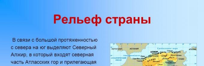
The north of the country occupies the central part of the Atlas Mountains. The two main mountain chains are the coastal atlas (Tel-Atlas) and the Sugar Atlas are interspersed with intergountain plains. In the south of the country there is a sugar desert (the Algeria accounts for most of its territory). Stony deserts are called Hamadami, and sandy - Ergami. In the south, in the Highlands Ahaggar, is the city of Tahat (3003 m), the highest point of the country. The climate of North Algeria is a subtropical Mediterranean. The climate of Algerian Sugar is a tropical desert, precipitation is less than 50 mm per year. The river network is developed weakly (the largest - r. Shelif). Most watercourses do not have a permanent drain. The vegetation cover and the soil of the North Algeria are typically Mediterranean. Among forests and shrubs, cork oak arrays are highlighted (mainly in the Tel-Atlas Mountains); In the semi-desert - Grass Alpha. Significant areas of sugar are deprived of vegetable cover. Nat. Parks: Jourjura, Akpha, Tassilin-Agere, etc.
Economy
Agricultural country. Mainly grain, grapes, vegetables, fruits are cultivated. The exports produce wine. In semi-desert areas - collection and primary processing of grass Alpha, going to the production of the best grades of paper. 95% of export receipts bring revenues from the sale of oil and gas. GNP per soul us. 1600 dollars (1995).
Monetary unit Algerian dinar.
Population
Most (approx 80%) population are Arabs. OK. 20% - Berbers, descendants of the oldest population of Algeria, consisting of several tribes, weakly interconnected. Nomadic tribes living in the desert, ch. Obra Taways. The official language is Arabic, French is widespread. State religion - Islam, the vast majority of the population of Sunni. In North Algeria, more than 95% of us lives. Countries mainly on a narrow coastal strip and in the Cabilia arrays. City population 56%. Density of 13.8 people. / km2. Large communities of Algerian Arabs are available in France, Belgium, USA.
Algeria - State in the north of Africa. In the West bordered by Morocco, Western Sugar, in the East - with Tunisia and Libya, in the south - with Niger, Mali and Mauritania.
The name of the country comes from Arabic El Jizair - "Islands".
Official name: Algerian People's Democratic Republic
Capital: Algeria
The area of \u200b\u200bthe land: 2381.7 thousand square meters. KM
General population: 34.6 million people
Administrative division: Divided by 48 Vilai (provinces).
Form of government: Republic.
Head of State: The president.
Population composition: 83% - Arabs, 15% - Berbers. Small groups of foreigners are still living: French, Spaniards, Italians, Turks, Jews, and others. Peoples.
Official language: Arabic (official), Berber dialects, spread French.
Religion: 99% - Muslims (Sunits), 1% - Others.
Internet domain: .dz
Voltage in the power grid: ~ 230 V, 50 Hz
Country Code: +213
Country barcode: 613
Climate
The geographical location of Algeria is the northern part of the African continent. Very large in the climate and nature of Algeria has its separation of the territory into two parts. One part is the coast of the Mediterranean Sea, the second is the Algerian desert. Therefore, this state on one territory has two different climatic conditions, as well as the nature of the vegetable and animal world. The climate of the state is also divided into two parts of the country. In the north, subtropical Mediterranean, and desert-tropical on the territory of Algerian Sahara.
In the country, on the northern part there are Atlas Mountains. The desert also consists of two species rocky desert and sandy. The state prevails mainly a warm climate. The average temperature in the Mediterranean part is +17 degrees, in winter it drops to +12, and in summer +25 and sometimes higher. In the desert areas +33., And the precipitation is a very small amount, but here, very often you can observe winds that create desert storms.
Also in Algeria there are frosts that are noticed by weather forecasters annually. Sometimes the precipitates are superior to the norms, this is due to the two main air fronts in the northern part of Algeria - polar and tropical. A very complex and diverse relief, this plain of the desert and mountains, also affect the climate, so different climatic conditions are often observed. In the coastal part of Algeria, very high humidity, which is seriously transferred by residents. Large difficulties creates uneven precipitation.
The rainy season in Algeria is very different from a similar phenomenon in all Africa, abundant precipitates fall out often and the frequent is a strong tropical rain, which is however short-term.
Geography
One of the largest and developed countries of Africa is located in the north of the mainland. The territory of the country occupies the central part of the Atlas mining system and the north of the Sahara desert. It borders with Morocco in the West, with Tunisia and Libya - in the East, with Niger, Mali, Mauritania - in the south. From the north is washed by the waters of the Mediterranean.
Algeria belongs to the countries of Maghreb ("Arab West"). The relief of the Northern Algeria is represented by two main ridges - coastal (or Tel Atlas) and the Sahara Atlas and Intergorean Plains. The highest point is Mount Tahat (3003 m.) In Highlands Ahaggar.
The territory of Sugar is engaged in rocky deserts - Hamadami and Sandy - Ergami. The river network is poorly developed (the main river is a shelf), most of the rivers have been drying regularly.
Flora and fauna
Vegetable worldThe vegetation of the country reflects the dual character of Algerian nature: subtropical Mediterranean in the north and semi-desert and deserted in the south. Typical Mediterranean growing has always been developed only in the non-coastal coastal zone of tell-atlas and cabin arrays.
It is most brightly represented on the slopes facing the sea. This area due to the root soils and good humidification occupies a special place in the country's agriculture. Almost all lands can be reached here, valuable subtropical cultures (hail wine, citrus, oilseeds, fruit trees, etc.).
Now, in natural form, Mediterranean vegetation has been preserved only on not used by man cool slopes, in the highest arrays and semi-suicide areas. But in these places the vegetation is degraded, especially where there were no other forests. Only for the first half of the century of our century, the area under the forests decreased to 100 thousand hectares, and the reduction of forests began long before our era.
Now an important task for the country is the restoration of forests, which is closely associated with the problem of protecting slopes and other land from dangerous soil erosion. Everywhere in the north of the country, there are great works on planting forests on artificially terched slopes.
The originality of the vegetation cover of Algeria is manifested in the fact that often the Mediterranean vegetation borders directly with the semi-desert. This change of botanical zones is quite rare in nature, occurs at a relatively short distance.
Animal world
Even more than the vegetation, the animal world was depleted during the historical time, although it is very diverse. Two thousand years ago, it was from here for the spectacles of ancient Rome, most exotic animals were supplied. Just a hundred years ago, a hunt for Gazelle, Lviv, Ostrichs and other large animals was held in North Algeria, fully exterminated by the beginning of the XX century.
The basis of modern fauna is animals semi-deserts and deserts. Forest fauna has been preserved only in the islets of the least disturbed forests of Tell Atlas, Cabilia and Ores.
Magoberman Macake, which is still found in the forests of Telly and Cabulia, is presented primarily from mammals. Occasionally, hares come across, and the species, very far from the European relatives. In some places, the Mediterranean rabbits are inhabited, as everywhere, malicious pests of crops. Many types of volatile mice. From rodents in more southern regions, tushcans close to Asian species are common; Everywhere there are mice (forest, field), garden sony, from insectivorous earthrooks and hedgehogs.
Predators are now mainly representing small animals: this is a fox, a steppe cat, Aska and the otter in the north, and the south is still quite numerous vissels, hyenas, mynemmonamons, or mouse pharaohs. From the Sugar regions sometimes far to the north enter the barren cats, lynx caroda, jackals.
Small flock of gazelles remained from hoofs and very rarely in the south there are antelopes-buckl. On the border with sugar, dickeranes were recently met, the desert fenwoman fench comes from rare. Rarker became marine mammals off the coast of Algeria.
The world of feathered is rich, but there are few local species and endemics, and the overwhelming part of birds migratory or common views with southern Europe. In Algerian forests, the trills of our songs of birds sounds, the woodpeckers are knocking, chirping tits. There are numerous birds from the colleague and coronary families everywhere. In the inner regions of the North Algeria, you can hear the voice of the Lark, to see the crane-handsome, Kulikov and Herkel, and on the reservoirs of the span geese and ducks, sometimes surrounded somewhere in the Baltic States or near Moscow. Quite a lot in Algeria of predatory birds; Among them are not less than four types of eagles, falcons, hawks, kerms, etc.
Everywhere in the country you can see representatives of scaly reptiles. Particularly diverse lizards fine-pop, widespalled and fan-shaped gecko, gray warana, amphisbentes, scinting, etc. In the forests of Telle Atlas, innocuous chameleons live, who are often found in animal lovers.
There are more than 20 kinds of snakes, of which 7 poisonous. Snakes dwell everywhere. These are polishes and custody, forest violets and dangerous efa, or Mauritanian echidna, horned viper and viper Avicenna, African Cobra and Steppe. Conversable for bathrobes Meeting with sea snakes. The turtles are very characteristic, of which the marsh, or water, turtle is most common in the north. From the amphibians, in addition to lake frogs and the toad in the north of the country, you can see Salamander and Tritons.
Freshwater fish are not enough, but still in rivers and lakes you can engage in the fishery of acne, barley, Usacha, in some Mountain Ureah trout. In coastal waters, the usual Mediterranean fish Merlan, Dorada, Ma Crowt, Skumbria, Sardines, Anchovies, etc.
Everywhere you can meet representatives of spider saloon, or phalange, scorpion, etc. The carriers of severe diseases of people and animals are ticks. Among the very numerous insects, a lot of pests of agriculture, but the most dangerous locust, periodically devastating huge spaces in North Africa. Repeatedly from the end of the XIX century.
Algerians' vineyards were seriously suffering from Tley Filloxers. Another kind of Tley Koshenyle is ruined by landing olives and citrus. Some types of ants harm codes of cork oak. The fight against insect pests is one of the important business worries in the country.
sights
The attractions of Algeria include: the numerous ruins of the ancient cities of the Phoenicians, Carthaginian, Romans and Byzantines on the country's coast.
The capital of the country is the ancient city of Algeria, spread out the amphitheater on the hills of the Bay of the same name. Most of the buildings are constructed from light building material that gives the city an elegant look. The Arab "Kasba" is originally in the old part of the city with a bizarre disorder of narrow streets and one-story houses with flat roofs, slender mosques and other buildings in oriental style. Among them are allocated built in the XVII century Mosque-tomb Sidd Abterrachman and the Mosque Jami-Al-Jadid, the Old Town, the Museum of Ancient History and Antiquity. In Oren - a big mosque (XVII century) and the Citadel (XVIII century).
Banks and currency
Algerian dinar equal to 100 centimams. The use of other currencies is prohibited, the use of credit cards and tourist checks is difficult, possibly only in the capital. Currency exchange can be made only in banks and official exchange offices.Useful information for tourists
The traditional way of life of Arabs in rural areas is an association under one roof of several families of different generations. Head of Family - Father. Men work, attend public institutions familiar. Women care about the house and raise children, their closed lifestyle is dictated by the Quran. In cities, every family lives separately. The traditional clothes of women are white hijab (bedspread), which it closes everything except the eyes. Most citizens wear European clothing.The geographical location of Algeria is one of the major countries in Africa, since the country area is about 2.4 million square meters, and a length from north to south almost 2000 km!. This state is located in the northwestern of the mainland. In the north it is washed by the Mediterranean Sea, the length of the coastline is 998 km. Algeria borders Morocco, Western Sugar, Mauritania in the West, Libya and Tunisia in the East, Niger in the Southeast and Mali in the Southeland. The capital of Algeria is located in the north of the country.
The relief of the country in connection with the high length from the north to the south is distinguished by North Algeria, which includes the northern part of the atlask mountains and the adjacent coastal plain and Algerian sugar, in the south-east of which the Highlands of Ahaggar is raised, where the highest point of Algeria Mount Tahkhat, whose height is located It is 2906 meters! From all sides, Highlands is surrounded by stepped plateaus and Miudir mountains.

Mountain Atlas amazed with her beauty! The ridges of these mountains, rising high up, end with sharp vertices and sheer cliffs. They are separated by high plateau and arrays alternating with intermountain plains and are cut by deep gorges. These mountains were formed in the Alpine Foldness, so earthquakes still occur here, the last of which was in 2003. The southern slopes of the mountain is a transition from the Mediterranean to Sahara.

The big part (about 90%) of the country is engaged in the stony and sandy deserts of the Sahara. North Algerian Sugar lies 26 meters below sea level! Here, Algerians are engaged in animal husbandry, leading a nomadic lifestyle is breed sheep, goats, camels. Agriculture is possible only in oases, where the population grows herd palm trees, the fruits of whom - dinips - replace their bread and potatoes. Under the thick crown of these palm trees, grain crops and fruit trees can be grown.

The climatic conditions of the climate of the North Algeria are typically Mediterranean with an average annual temperature of + 16 degrees and an average annual precipitation from 200 to 1200 mm. Vegetation is presented here with tight evergreen forests and shrubs. In the mountains of the Atlas, forests of stone and cork oak, allephask pine, juniper, Tui, Atlas Cedar and Falls of Trees are growing. However, the natural vegetation of these places was very much suffered from human activity. The slopes of the mountains were previously covered with cedar and pine forests, but as a result of cutting, fires and grazing of livestock they turned into a shrub coated shrub! For medium heights, shrubs and forests are characteristic of cork oak. The climate of Sahara desert tropical with an average annual precipitation of less than 50 mm and daily air fluctuations about 30 degrees! Vegetation is presented mainly by Solyankas and Efemera.

Minerals Algeria are one of the richest mineral resources in Africa. In the east of the country, oil is produced, and in the northern deserted parties and natural gas. In the atlas of the mountains, polymetallic ores are locked. The country has large reserves of phosphorites, iron and manganese and lead and copper ores, mercury, antimony. In connection with their development, even in the desert there were modern villages in which the mining and intelligence officers live. Roads are laid between large cities, pipelines are built, oil processing plants, metal smelting.

Animal world Animal world Algeria is poor and almost exterminated by man. In the forests of satin, hares, boars and macaques are preserved, and in Sugar - Cheetahs, Jacales, Hyien, Fenca Fox, Gazelle, Antelope Addax, Birds, Small Rodents, Snakes, Lizards, Turtles, From Invertebrates, Sonorchal, Scorpions, etc.

Internal waters All Algeria Rivers are temporary watercourses (WED) filled in the rainy season. The Rivers of the Far North of the country fell into the Mediterranean Sea, the rest are lost in the sands of the Sahara. They are used for irrigation and water supply, for which they are built with reservoirs and hydropower plants. The largest river Shelief (700 km). The lakes of lakes (Sechchi) are also filled in the rainy period, and in the summer they dry and are covered with salt crusts with a thickness of up to 60 cm. In sugar in areas of large groundwater reserves, the largest oasis are located.

The population is a population of 34.6 million (Evaluation for July 2010), most of which live in cities (65%). In addition to the Arabs that make up 83% of the country's population, Berbers live here (16%), as well as Europeans (French, Spaniards, Italians), Turks and Jews. State language Arabic, but French and Berber dialects are widespread. The main religion is Islam, 99% of the population of Algeria are confirmed.

The economy of Algeria is the basis of the economy of Algeria gas and oil. They give 30% of GDP, 60% of the profitable part of the state budget, 95% of export revenue. According to the reserves of Gaza Algeria takes 8th place in the world and the 4th place in the world in the export of gas. According to the reserves of Oil Algeria in the 15th place in the world and at the 11th place for its export. Algeria's authorities make efforts to diversify the economy and attract foreign and internal investments in other industries. Structural changes in the economy, such as the development of the banking sector and the construction of infrastructure go slowly, partly due to corruption and bureaucracy. In the agricultural sphere, agriculture export directions prevails. The main cultures of grapes, citrus, olives, dates and tobacco Algerians are grown in subtropics, in the coastal strip and mountain valleys. Almost 1/3 of the lands are not used in agriculture, as they are busy deserts.

Economic and geographical characteristics of Algeria
1. Introduction 3.
2. Natural conditions 5
3. Geography of the population 8
4. Geography Industry 9
5. Geography of agriculture 11
6. Transport Geography 14
7. External Economic Communications 15
8. Conclusion 16.
9. List of references 17
1. Introduction
Algeria (by the name of Algeria, from Arabic al-Jazzair - Islands), (Arabic - Al-Jumhuria al-Jesiairiya Democracy Ash-Sharabia) -
- State in North Africa, located in the western part of the Mediterranean basin., Where are the important global ways between the Atlantic and the Middle East, Europe and African countries. It borders: in the West with Morocco and Western Sugar, in the south-west with Mauritania and Mali, in the south-east with Niger, in the east with Libya and Tunisia. From the north, the territory is washed by the Mediterranean Sea. Area 2381700 square. km. Population 29.3 million people. (1998). Capital - Mountains. Algeria (3 million inhabitants). Large cities Oran (700 thousand people), Constantine (600), Annaba (400). Arabs make up 80%, Berbers - 19% (cabin, choui, taways), the rest are 1%.
Most of the population of Algeria - Muslim Sunni (Malikita and Hanafis). Some followers of the Ibadites sectors live in the Mzab Valley, Wargle and Algeria. The state religion of the country is Islam. There are approx. 150 thousand Christians, mostly Catholics, and approximately 1 thousand adherents of Judaism. The state language is Arabic, but the French language is still widespread. Some Berber tribes who speakers in Tamahak and Tamazirt found their writing. A few books have already come to the Tamazirt in Algeria's dialect. About 3/4 of the population focused in the foothills of the Tel-Atlas, approximately 1.5 million people live in the area of \u200b\u200bthe highland and less than one million in the Sahara desert. The greatest density is noted near the capital and in the Cabulia region. Length of railways 4.2 thousand square meters. km, road length 102 thousand km. Geographical position |
Algeria occupies the central part of the Atlas mountain range and 1/4 of the Sahara desert.
The territory of the country is 2381.7 thousand square meters. km.
Climate of North Algeria subtropical. The average temperature of January 5 - 12C, July 25c. Precipitation 400 - 1200 mm per year. The central and southern part of the country are occupied by the desert sugar, where the average daily temperature fluctuations reaches 30 S. Sugara tropical climate, desert (less than 50 mm of precipitation per year).
Forests of cork oak (in the mountains), semi-desert and desert vegetation.
Form of government -
Republic
Administrative and territorial division - 48 Vilay (provinces)
Head of State - President
Legislative Body - Single-Paral National People's Assembly
The country refers to developing, to a key subgroup.
2.Priery
Algeria occupies the central part of the Atlas and Sugar Desert. Washed by the Mediterranean Sea. The coastal part lies in the northern subtropical belt, the rest of the territory - in the tropical belt of the northern hemisphere.
The shores are predominantly high, rocky, with non-sturgee beaches. On all the coast, there are no deep-smoking bays deeply; The number of large bays is insignificant (Orange, Algeria, Bedjaia, Annaba).
Relief. The North Algeria is represented by folded ridges, arrays and intermountain plains of the system of the Atlas Mountains. Within Algeria, the largest rates of Atlas - Tel Atlas and the Sahara Atlas, Warsenis Massives (Sidi-Amar, 1985 m), B. Cabilia and M. Cabilia (high to 1200 m), Kohn, Ores (Shelia, 2328 m ). The mountains are cut by deep river gorges, smaller arrays are divided into separate domidates. Large intermountain plains and a plateau (t. High plateau) in central parts are engaged in large salty lakes - seccami.
Algerian sugar occupies the central part of the world's largest deserted sugar field. In the relief, it is dominated by a plateau with a height of about 500 m. On S.-V.- large lowland, filled with sands, and a salty lake Schott-Melgir (26 m below Ur. Sea). On Yu.-v. Extensive volcoloch. Highlands Ahaggar with an array of atakor (Tahat, 3003 m - the highest vertex of Algeria), surrounded by the system of stepped plateau (Tademait, Tassilin-Agere, Midir, etc.). Within Algeria, large sandy deserts with high dune ridges are located (large western Erg, Big East Erg, Ergy Igidi, Shesh, etc.) and stony deserts (Tanz-Ruft on Yu.).
Geological structure and minerals. The territory of Algeria within the limits of Atlas Mountains belongs to the Mediterranean geosyncline folded belt, and in the area of \u200b\u200bSugar - an ancient African platform. There are large deposits of oil and natural gas (Hassi Melas, etc.), which constitute the main wealth of Algeria. The atlas is known for the Iron (Magryb), copper, lead and zinc ores, phosphorites, mercury, antimony, barite, Kizelur, stone coal, etc.
Climate. In North Algeria, climate subtropical, Mediterranean with warm rainy winter and hot, dry summer. Cf. January temperature on the coast 12 ° С, on intergigurny plains 5 ° C, July 25 ° C. The absolute maximum temperature is everywhere above 40 ° C. Frequent droughts. The main part of the precipitation falls in November - January (in Tel Atlas 400 - 800 mm, in the cab in arrays up to 1200 mm and more than a year). In winter, the mountains in the mountain ranges at the tops are up to 10-20 days and the snow is kept. In the transition zone to Algerian Sahara, the climate is more arid, semi-desert (Wed. Temp-July July above 30 ° C, precipitation 200-400 mm per year). In Sahara, the climate is deserted, extremely dry (less than 50 mm of precipitation a year, in some years it does not happen at all). Daily fluctuations in the Temp-p reach up to 30 ° C (in the summer of 40 ° C and above, at night 20 ° C, in winter, the day is approx. 20 ° C, at night drops to 0 ° and below). Dry winds often cause sandy storms.
Inland waters. All Algeria Rivers belong to the type of weds. Weda North Algeria is close to mediterranean rivers with a predominance of rain food. Only in the coastal zone of the Watets are directed to the Mediterranean Sea. In the rest of the Algeria-closed indoor basins. Water expenses in Mediterranean WEDAs range from 0-2 m cubic meters. In seconds in the summer, up to 1000 m cubic meters and more in the flood after the rains. Frections are short but strong floods. The largest Wed - Shelif (700 km), the remaining WEDs are rarely exceeded along the length of 100 km (El Hamman, Issis, sums, el-kebire, etc.). Dams, reservoirs and hydroelectric power plants are built on the Weta North Algeria. Waters are used for irrigation (St. 100 thousand hectares). Most of the salty lakes (Cex) lies in the intermountains (Schott-Eshang, Schott-El-Khdan, Zinc-Sherga, Zinc-Garbi, etc.) or depressions (Schott Melgir). Sugara has large groundwater reserves, especially in the northern part, where the largest oasis (Tydicult, Tuggurt, El Golea) are located.
Soil. In North Algeria, the zonal type of soil-brown (carbonate and leached in tel atlas, gray-brown in semi-desert areas). High resistance is manifested in variants of brown and brown forest soils. In the foothills are common arrays of salt marshes around themselves. Sugar is dominated by crubstone soils of subtropical deserts, waving and semi-rained sands.
Vegetation. On the coast, the vegetation of Mediterranean type with dry tight forests and shrubs. Altitude exemplary is well expressed in the mountains: up to 800-1000 m - the belt of evergreen urban thickets of shrubs and low-spirited trees (McVis), mainly an aliens (olive tree, pistachio, etc.), above - forests from the cork and evergreen (stone) oak and Falls, from 1200 to 1500 m - belt of alek pine, from 1500 to 2000 m - juniper and thuja, there are cedar glands above 2000 m. To the south of Tel-Atlas, the vegetation acquires a semi-desert character with the predominance of cereals and wormies. Vegetable cover is strongly degraded. Only individual arrays of forests have been preserved. In Sahara - Solyanka, ephemeral plants in the sands after short spring rains, cereals (Sugar Digger, ephedra, drin), shrubs - types of acacia, yuuba.
Animal world. Large mammals (lions, leopards, gazelles, etc.) and birds (ostriches, cormorants) are very exterminated. Berber Macaka (Mago), hare, rabbit are preserved from mammals in North Algeria; In the north of Algerian Sahara - Hyena, Geneltta, Jackal, Fenca Fox; Rarely encountered gazelles and antelope. Many small rodents (tubes, etc.), bats, birds of prey. Very many reptiles (lizards, varana, more than 20 types of snakes, turtles) and insects (especially harmful - locust), as well as phalange, scorpions, ticks.
3. Geography of the population
2 Type of reproduction - demographic explosion. Birth rate 35-40 per 1000 people in the population for 1 year. Mortality 5-10 per 1000 people per 1 year. Natural increase-over 30. The composition of the population is the predominance of the male population. Average life expectancy: Men - 67, women - 69.
The main population of the country is Algerians, which make up more than 98% of the total population. Consist from Arabs and very close to them in the language and culture of Berber.
Most of the indigenous population speaks at the Algerian dialect of Arabic (81.5%). Dialects of Berber Language, which speaks. 17.9%, preserved mainly among the Berber populations of the country's mountainous regions and some oases of Algerian Sugar (Cabil, Chaying, Tuaregi). Among the population of large cities, French is also distributed (it says 0.4%). According to religion, Arabs and Berbers are Muslim Sunni.
Over 4% of the population lives abroad, mainly in France and Belgium. After 1962, as a result of mass departure from Algeria, the French, their number declined from 1 million people. (1960) to 68.4 thousand (1966).
The population is posted on the territory. Extremely unevenly. More than 95% of the country's total population lives in North Algeria, and its main part is concentrated in a narrow coastal strip. The most densely populated the Cabilia, where the density reaches more than 300 people. per quarter. km, with an average density in the country of 12.3 people. per quarter. km. In Algerian Sahara, density is less than 1 person. per quarter. km. Rural residents that make up the majority of the country's population lead a settling, semi-seated or nomadic lifestyle. In the western and central part of the Northern Algeria, a settled population is prevailing in the main field. Children's chores and nomads inhabitants inhabit the so-called high plateau, the Sugar Atlas and Sugar. The sedentary population of the desert is the inhabitants of oasis and mining centers. Demographic growth of 2.6%,
4. Geography industry
Industry. The share of the mining industry and energy accounts for more than 1/3 of the country's gross industrial products. The leading among these industries is oil and gas producing. In the northern and eastern regions of Sahara are open after the 2nd World War I, the main Algerian fields of oil and natural gas of world importance (oil reserves are estimated by about 1 billion tons, gas - 3000 billion cubic meters. M).). The annual oil production is about 60 million tons. Oil pipelines enters the Mediterranean ports, from where it is exported mainly to France (70% of all oil). Part of the oil goes to refineries in Algeria and El Harrash, approximately half of the petroleum products are exported.
Natural gas was also important - 3288 million cubic meters. m in 1968; 43 billion cubic meters. M - In 1997, 3 fields are operated - Hassi-RMel (gives approx. 9/10 of all gas production), In-Amenas and Hassi Mealya (in the way with oil). According to the gas pipeline, methane is transmitted to the coast, where most of it liquefies at the plant in Arzev and is exported mainly to England and France. Expands the use of natural gases within the country; Gasified cities of Algeria, Oran, Mostagan, etc.
Development of ore fossils are concentrated in North Algeria. Among them, the first place is the mining of iron ore, which comes mainly on exports. Major mines - Unce (St. 50% of all extraction), bu-frame. The mining of lead-zinc ores is important. The development of them is carried out in the WED-Zunder and Wed-Abed fields, as well as in small quantities in Sidi-Camber and Warsenis. Freeding phosphorites due to the development of the El Qiif field decreased. The new large deposit is jebel-onk, which is put into operation. Minor coal developments are underway (in Kenadza, at S.-Z. Algerian Sahara), copper ore (in Ain-Barbar near the city of Annaba, 4.6 thousand tons per year), as well as iron polegan, barite, Surimes, Kizeligra. The largest iron ore deposits in Maghreb (Gara-Jebilet, near Tindouf) and a large mercury deposit (in Northern Algeria). Electricity production is 1.2-1.3 billion kWh, including about 780 million kWh (the most important TPPs in GG. Algeria, Annaba, Oran, Beshar).
Main industry manufacturing industries: dude (approx. 1/2 of all products), metalworking, textile and sewing, refineries, chemical and leather-shoe, cement (minor and partly medium enterprises dominate). Distributed and canned plants, tobacco factories, grain processing enterprises and the production of olive oil are accommodated in almost all cities of North Algeria. Textile industry, including handicraft production of carpets, is located in GG. Algeria, Oran, Annaba, Tlemsen. The metalworking industry is represented by small mechanical and repair workshops, car-building and pipe rolling plants, etc. Its main center - Algeria (assembly plants of passenger and trucks); In El Harrash - tractor collectors. In Annaba, with the assistance of the USSR and other countries, the metallurgical plant was built (in 1968 the 1st turn of the plant with a capacity of 400 thousand tons per year). The chemical industry is developing: plants for the production of superphosphate, sulfuric acid, copper sulfate, cellulose, etc.-in gg. Algeria, Oran and Annaba. Built (1969) large S-D nitrogen fertilizers and ammonia in the city of Arzev. Cement plants (with a total capacity of about 1 million tons every year) are in the GG. Algeria and Oran. Algeria received a variety of economic and scientific and technical assistance to the USSR, which provided large loans and supplying the latest equipment for the constructed enterprises; Organized and operates the Institute of Oil and Gas in G, Bumerdes (near the capital), transmitted together with the technical school as a gift to the people of Algeria.
5. Geography of agriculture
Agriculture - a branch in which the bulk of the population of Algeria is busy. Agricultural land, including forest land, occupy. 44.2 million hectares, or about 1/5 of the entire territory, of which 7-10 million hectares (depending on climatic conditions) are processed land (almost everything in Northern Algeria). At the first stage of the agricultural reform (1962-64), the lands of European colonists were expropriated and collective X-Wa was created at the head of self-government committees. The self-governing sector in 1966 consisted of 2,200 hosts in a total area of \u200b\u200b2400 thousand hectares, including 30% x-in sizes over 1-2 thousand hectares each. They are posted on the most fertile lands, and half of them - in the plains of the North-West (Vilaya Oran, Mostagan, Tiatset). The share of X-in this sector accounts for 24% of all arable land, 65% of lands with fruit plantings, 60% of all crop production, 5% of animal husbandry. The old peasant sector covers 650 thousand x-in, of which 600 thousand X-Bs have less than 10 hectares of Earth each, including 350 thousand x-in - less than 2 hectares.
In 1988, agricultural reform was carried out. State bodies were dissolved. On their basis, 22 thousand small cooperatives were formed. Part of the lands were transferred to the peasants.
Agriculture gives about 3/4 of the whole S.-H. Algeria products. The main place (over 4/5) in the sowing grounds occupy grain crops. Baggy farmer farming dominates in Algeria, irrigated lands do not exceed 250-300 thousand hectares. The solid wheat is cultivated mainly in the inner areas of the body, soft - in the north-west. The yield of grain in small X-WAH on average does not exceed (except rice) 3-8 c / ha. Algeria is forced to systematically import grain (2300 - 3000 thousand c per year). The economies of the Community Sector give approximately 1/3 of the entire collection of wheat, barley and oats and about 2/3 - corn, sorghum and rice.
Especially important is viticulture and winemaking that gave in the 50s. About 1/3 of all gross products and 1/2 Algerian exports (in price). The main vineyards are located in the northwestern. Algeria (in the area of \u200b\u200bOran more than 1/2 of their entire area).
Most of the wine is exported to France. After 1962, France significantly reduces the procurement of wine in Algeria, which is sharply reflected in the position of viticulture in the country. Supplied to export wine is 1.7 million Gl.
A significant role is also played by the production of citrus, especially oranges (on the plain of Mitijah, in the Shelda Valley), most of which are exported to European countries.
Olive tree has long been cultivated, especially in the Cabilia (approx. 2/5 of the entire collection of olives); Olive oil (on average about 20 thousand tons per year) is consumed mainly within the country. In oases, the Sahara cultivate the chipstick. On the coast, near major cities, the cultivation of early vegetables is developed (approx. 6 million c per year), tomatoes, artichokes, carrots, as well as potatoes sold in European markets. The common sector accounts for approximately 92% of the total citrus crop, 34% of olives, 8% of dates and 45% of vegetables. From technical crops, they cultivate tobacco, mainly in Mitijah and the Cabilia, which is in most exports (about 10 thousand tons per year).
Livestock is extensive, it gives almost 1/4 of the whole S.-H. Products, but in the inner areas, on the elevated plains and the plateau, especially in Sahara, often serves as the main and even the only source of the existence of democrebers and nomads. For the population of the mountain and coastal regions of the North Algeria, there is a distinguished pasture or mining and pasture cattle breeding in combination with agriculture. The livestock of cattle is 1.5 million heads, sheep - 15 million heads.
Forestry and fishing. Forests and shrubs (general pl. 3 million hectares) are preserved mainly in the mountains of Tel-Atlas. The main economic importance is the arrays of cork oak (the workpiece 300-600 thousand c tubing in a year - 3rd place in the world). The main part of the raw material is processed on state enterprises and is exported. In semi-desert district (Vilaya Tiat, Said, Medea), the collection and primary processing of alpha grass (total pl. Ok. 4 million hectares). Alpha raw materials (90-100 thousand tons every year - 1st place in the world) is mainly in the production of the best grades of paper, cellulose, wicker products.
Fisheries (mainly Sardin, Herring, Anchovy) developed weakly (cf. catch approx. 20 thousand tons per year). Measures are taken to increase marine fishery and fishing ports are reconstructed (Beni-Saf, Oran, Tennes, Sherchel, etc.).
Livestock livestock (in thousands of heads)
Dilsert sheep, goats, cattle, camels.
Land structure in use (in thousand hectares)
6. Transport geography
An important role is played by iron. Morning, the total length of which is 4.2 thousand km, including with norms. Kolayuy 2.6 thousand km; Basic J.-D. Mainstream between the city of Huddish (Morocco) and Gardimau (Zap. Tunisia) through the GG. Oran, Algeria and Constantine connect the most important economic centers of North. Algeria. From ch. The highways move lines on S., to seaports, and on Yu., To mining developments and oases. Sahara. Total freight turnover 960-980 million T-km.
The length of the network of highways is 50.2 thousand km. Along the coast, the main motorway is held, from which highway roads are branched in the northern and southern directions. After 1962, the Adrar - Besar (720 km), Beshar - Tindouf (900 km), In-Amenas - Ghadames were built.
The pipeline transport is developed (the total length of oil pipelines is about 3 thousand km, gas pipelines - more than 1000 km). There are large oil pipelines: In-Ame-us-Sekhir (Tunisia), Hassi Melaud - Bedjai, Hassi Mesaud - Arzev, Beni-Mansur - Algeria and Hassi-Ramel gas pipelines - Arzev, Mescard - Skiqda (700 km) and Gas pipeline Hassi-Rhere - SkiKda.
Sea transport provides almost all foreign trade transportation. In terms of cargo turnover, ports (thousand tons) are highlighted: Bearia - 15.3, Arzov - 9.1, Algeria - 4.4, Annaba - 19.2, Oran - 1.8.
Air transport develops rapidly. In the country, 65 airfields, of which are 31 civilians. Airports of international importance are located near. Algeria (Dar-El Beida), Annaba and Oran (La Singles).
7. Ensuring economic ties
The volume of foreign trade in countries is $ 5-25 billion.
Export - 100% (fuel).
Imports: Machines and equipment, food, agricultural raw materials, chemical products, etc.
Until 1962, the total volume of foreign trade turnover was over half of the gross national product of Algeria. After establishing the political independence, Algeria goes along the way to overcoming one-sided dependence on foreign markets and capital, strengthening the state monopoly in external relations. In 1967, the state controlled 90% of exports and 75% of imports. France, England, Germany, Italy, Morocco and Tunisia until 1962 did a 90% of all Algerian foreign trade turnover, including 80% - to France. In the 60s. This share is reduced as a result of increased trade relations with socialist and developing countries. In 1965, the share of France in Algerian imports was 70%, and in export 76%. The main export goods in the countries listed above are: oil (approx. 2/3 of the total value of Alge. Export), wine (15%), fruits and vegetables (12%), iron ore (3%), tobacco paper. Algeria imports industrial equipment, food products (especially grain, milk, meat), as well as light industry products (synthetic fabrics, textiles) and metals (the last importation of the latter has been supplied since 1967. under strict control).
Agreements on economic cooperation, including financial assistance, Algeria concluded from the USSR, PRC, Yugoslavia, Bulgaria. Czechoslovakia, Oar, Kuwait. Agreements are available with France, England, USA, the International Bank for Reconstruction and Development and the European Development Fund.
Currently, external trade with EU countries accounts for more than 60%, USA - 17%. External trade turnover is $ 22.6 billion (1997). Export: oil and petroleum products - 51.7 million tons (1997); Natural gas - 43 billion cubic meters. m; Wine, citruses, traffic jams, building materials.
In November 1996, the Magreb gas pipeline was commissioned - Spain. In 1997, Gas 4 billion cubic gas was delivered to Spain. m, in Portugal - 400 million cubic meters. m.
The financial position of Algeria is determined by income from oil and gas (up to 98% of foreign exchange earnings and about 66% of the revenue part of the state budget. Algeria gold reserves - more than 9 billion dollars.
In recent years, on objective reasons, the financial situation of Algeria worsened, external debt increased significantly (34 billion in 1997). As a result of negotiations with the International Monetary Fund, Parisian and London clubs, an agreement was reached on the reeechelonization of most of the debt.
The growing financial and economic difficulties led to an increase in inflation, prices, deterioration of the population (over 2.5 million unemployed, mostly young people. More than 1 million Algair residents work in Western Europe. The property bundle of society is deepened.
Algeria is a country with ancient history of the grunge wars and colonization, both African and Eurasian states. The main influence was the Arabs, which began their culture, language, religion (Islam). Berbers - the descendants of the historically indigenous population - Libyans, constitute an absolute minority.
The formation of Algeria as state contributed to its favorable geographical position - there are important global ways between the Atlantic and the Middle East, Europe and African countries.
Andrew is the Parliamentary Presidential Republic with the very broad powers of the president.
Algeria is a stately developed in economic and cultural relations. The standard of living of the population is relatively high, supported by subsidies from the state, mainly due to exports of oil, gas, etc. Free training and medical care. Much attention is paid to education.
Andrew is a state characterized by political instability, the army plays a major role in the containment. The main factor in political instability is the struggle for power, both between political movements and within them. The main disturbants of political life are IFS and Hamas. They constitute the main opposition to the state rate (the construction of socialism, the establishment of the presidential regime, the single-party system, etc.). One of the main factors used by the opposition are unemployment, economic difficulties, etc. Instead of the Constitution, they nominate the laws of Sharia - Quran. The main methods of struggle against extremist Islamic organizations are international and internal terrorism.
The economic base of Algeria is natural resources (oil, gas, ore, etc.) and nationalized foreign possessions, firms, companies, banks, property, etc.
In the Algerian economy in recent years there has been a transition from a planned market; It is allowed to buy land from the State Fund, unprofitable cooperatives; Most trading went into private hands.
There are still problems in health care: the fight against infectious and environmental diseases, as well as in veterinary medicine - the struggle against animal diseases, including dangerous for a person.
LITERATURE:
Asia and Africa today. Journal No. 9, P. 19-21. M., 1996.
Africa. General review. North Africa. In the book: countries and peoples. Scientific and popular geographic ethnographic edition in 20 volumes. M., "Thought". 1982. P. 251-291.
Great Soviet Encyclopedia. In 30 volumes. Edition 3rd. Volume 1. M., "Soviet Encyclopedia", 1969. P. 422-434.
World countries today. Volume 3. Africa. Algeria. M., 1999.
Countries of the world. Directory. Ed. I.S. Ivanova. M., "Republic". 1999. P. 13-15.
Echo planets. Journal No. 3 M., 1997.
Echo planets. Magazine No. 4 M., 1998. P. 11.
Algeria is located in the north of Africa. One of the largest countries of the continent. The total area of \u200b\u200bthe country is 2,381,740 km2. The length of the coastline is 998 km.
One of the largest and developed countries of Africa is located in the north of the mainland. The territory of the country occupies the central part of the Atlas mining system and the north of the Sahara desert. The relief of the Northern Algeria is represented by two main ridges - coastal (or Tel Atlas) and the Sahara Atlas and Intergorean Plains. The highest point is Mount Tahat (3003 m.) In Highlands Ahaggar. The territory of Sugar is engaged in rocky deserts - Hamadami and Sandy - Ergami. The river network is poorly developed (the main river is a shelf), most of the rivers have been drying regularly. It borders with Morocco in the West, with Tunisia and Libya - in the East, with Niger, Mali, Mauritania - in the south. From the north is washed by the waters of the Mediterranean. Algeria belongs to the countries of Maghreb ("Arab West"). The total area of \u200b\u200bAlgeria is 2381.7 thousand square meters. km.
Nature Algeria
Passing in the north along the coast of the Mountain chain of Tell-Atlas cut through the few bays and plains. The lowlands around the cities of Algeria and Oran are tightly populated. Small bays are used for fisheries, the export of iron ore and oil. Tel-Atlas rises above sea level by more than 1830 m and includes arrays of the Tlemsen, a large and small chamber and manger.
Mediterranean type shrubs and cork oak forest are found at medium heights. At higher marks, cedar and pine forests have once grown, but as a result of cutting, fires and grazers of livestock, many mountain areas have turned into a waste-covered shrub. The climate is Mediterranean, with hot, dry summer and warm rainy winter. In winter, the snow covers only the highest peaks. The spread of average annual precipitation is from 760 mm on the coast up to 1270 mm on the slopes facing the sea and less than 640 mm on its inner slopes.
The southern part of the tell-atlas is a high plateau with a medium height of 1070 m. This area is characterized by semi-sirid climatic conditions with an annual precipitation of 250-510 mm. In more moisturized areas, they cultivate grain and grass alpha (Esparto), the fibers of which serve for the manufacture of ropes, fabrics and high-quality paper. Salt lakes (called Schott) and Solonchaki are found at lower lines with a dry climate. Located even further to the south, the Sahara Atlas rises to a height of 150 m above the plateau level and then drops to sugar by more than 300 m. The most sublime part of the Sahara Atlas is the Mountain Systems of Xur, Amur and Calm-Nail. Annual precipitation on the northern slopes is approx. 510 mm, on the southern - 200 mm. Thanks to the abundant herbal intercourse, the Sahara Atlas serves as a comfortable area of \u200b\u200bgrazing.
Statistical indicators of Algeria
(as of 2012)
The rest of the country is the Sahara desert. The average height mark in Sugar is approx. 460 m. In the area of \u200b\u200bthe Array of Ahaggar (Hoggar) near the southern border of Algeria, the highest peak of the country Mount Tahahat - 2908 m. The sugar must be occupied by crubstone and pests (Hamada and Region), and approximately 1/4 part - sandy deserts (Ergy) . In the afternoon it is hot, sometimes the temperature reaches 35 °, but the nights are cool. The precipitation is extremely rare. In oases, in conditions of constant irrigation, the palm palm tree is growing. In Algeria, only a few rivers have a constant drain, the rest are powered by precipitation. The sources of water supply serve wells, dug in the dry rivers (Wadi), in many places groundwater, entering the surface through artesian wells and Foggar - horizontal tunnels, dug under a slight bias.
Geological structure of Algeria
In the territory of Algeria, various areas of the region are distinguished on the geological structure and metal generation - the Sugar (part of the ancient African platform) and the Atlas (sector of the Mediterranean geosynclinal belt) separated by a south-attcent factor. In the south of the Sakhak region, the shield of Ahaggar (Hoggar) is distinguished, in the south-west - El Elamb (regions). They are complicated by the crystal rocks of the Archey, metamorphic by volcanogenic and debris and carbonate sediments of the lower proteoda and reefoy-vend. Geosyncinal orogenic volcanogenic sediments, the Granites of Taurirt (650-500 million years) are also widely developed in Ahaggare. The platform case is formed by the marine terribution-carbonate sediments of Rephey-Venda (especially in the regional massif), lagunno-continental and sea deposits of Paleozoic (power of 1.2-3.8 km), sandstones and evaporites of Triass, clays and sandstones of Yura - Neogen.
In the case of the Sugar Plate, syneclides (Tinduf, West and East-Sugar) separated by raising, and an avgart zone, which is Austcogen, whose folding was manifested at the end of the carbon. With volcanics and granites of Rifey - Venda are connected by the ores of uranium, tin, tungsten, rare metals and gold in Ahaggar. In the synisc loophole, the largest deposits of iron ores are localized among the Paleozoic clay and sand deposits of the platform cover, in the south of Ahaggar - promising uranium deposits. Anticline in the deposits of the Cover on the Northern Delight of Ahaggar accommodate unique deposits of oil (Hassi Melaud) and Gas (Hassi-Rhere).
In the folded Atlas area, evaporites, gypsum-bearing clays and red-colored triad chip breeds are developed, blocked by sea terribution-carbonate sediments and carbonate-terrigenous flies (Yura, chalk, paleogene). In the north, Neogen is represented by sea volcanogenic-sediment, clay-carbonate, in the south - continental sediments.
In the tel-atlas, the folded rocks of the mesozoic-Cenozoic (to the middle miocene inclusive) form a series of tectonic covers moved from the north to the south. In the coastal zone, the Andesites and the neogene granitoids are slightly developed, in arrays of a large and small cabin - metamorphic rocks of the Precambria and the shale of Paleozoic, which protrude on the surface. To the south of Tel-Atlas there is a platform block of high plateau (Orange Plate), where the folded gercy foundation is blocked by a low-power weak-formated mesozoic case - Cenozoic. In grinds are exposed to terrigenous and volcano-shale breeds of Paleozoic, crumpled and tendered by Gerchinsky granitoids. To the south of the high plateau there is a moderately folded zone of the Sahara Atlas, formed on the site of the Mesozoic Progress. In general, in the Atlas region, climbing folds and faults of the Eastern and Northeast (or "Atlasky") stretch prevail, as well as submeridional "Krasnomoral" faults imposed in the northern part of Algeria on Chayjah Tel Atlas. Longitudinal and transverse faults cause the placement of volcanics, evaporite diapirus and the most important rudon-zone zones with deposits of ores of black and non-ferrous metals in the Atlas region. In North Algeria with the rocks of the Mesozoic - Cenozoic, the deposits of ore iron, zinc, lead, copper, antimony, mercury and various types of non-metallic raw materials are connected.
The territory of Algeria is characterized by high seismicity, which is associated with moving on faults and shaggy in various zones of North Algeria. The most seismic Tel-Atlas (6-7 points), within its limits - coastal zones (Tennes Sherchel, Oran-Mostagan and Shelif).
Minerals Algeria
In Algeria, oil, natural gas, stone coal, ores of uranium, iron, manganese, copper, lead, zinc, mercury, antimony, gold, tin, tungsten, and phosphorites, Barita, etc., are open and explored.
According to oil reserves, Algeria occupies 3rd place in Africa. In the territory of Algeria, 183 fields of oil and gas are known, dedicated to the Algair-Libyan oil and gas pool; Most of the field is located in the northeast of the Sahara region. The largest oil field - Hassi Meal is localized in the sandstones of Cambrian-Ordovik. Significant stocks are the Zarzaitin, Hassi-Tuil, Hassi El Agreb, Tin Fu, Gourd El Baghel, and others. In terms of gas, Algeria ranks 1st in Africa. The largest gas field Hassi-Rumblees lies in Triass's sandstones; Significant gas reserves are explored at the Gurd-HYC deposits, Nezla, Wed-Numer, etc.
Stone coal reserves are insignificant, its deposits (Kenadza, Abadla, Mesarif) are concentrated in the sediments of the upper carbon in the Besar pool. The coals are fatty, sintering, medium-rich (8-20%), contain 20-35% volatile impurities and 2-3.5% sulfur.
According to the reserves of Rud Urania Algeria ranks 4th in Africa. Hydrothermal-core deposits of Uranian Timgauin ores, Tinef and Abankor are explored in Ahaggar (proved reserves of 12 thousand tons, the content of U3O8 20%); In the south of the shield, uranium manifestations in Paleozoic sandstones (Tahagart) are known.
According to the reserves of iron ore, Algeria is located on the 2nd place in Africa. In the North Algeria, the metasomatic deposits of iron ores in rhygenic limestones APTA (Jebel-Unce, Bu-Hadra), the total reserves of which are over 100 million tons, the content of FE 40-56%. In Syanklis, the Tindouf is revealed by the largest Devonian sedimentary deposits in Algeria - Gara-Jebilelet (total reserves of 2 billion tons, the content of Fe 50-57%) and Ibede-Abdelziz (2 billion tons, 50-55%). The stocks of manganese ores are insignificant, they are dedicated to the volcanogenic-hydrothermal deposit of the WED-GETTAR (total reserves of 1.5 million tons, the content of Fe 40-50%) in the Beshar region.
According to the reserves, leaders and zinc Algeria takes 2nd place in Africa. In North Algeria, stratiform, dwelling (televerminal) and lenticular residential (hydrothermal) deposits of polymetallic ores are developed. Stratiform deposits of lead and zinc ores are located in the carbonate sediments of Yura (El Abed, Degen), chalk (kerzeth-yusef, Malloull, Jebel-Ishmul), the veins in the sandy-clay breeds of the chalk (Herruuma, Sakakod) are associated with the diapira of Triass Evaporites. Volcanogenic and plutonogenic-hydrothermal copper-polymetallic fields in the breeds of the chalk - Neogen are associated with Miocene volcanites (bu-sufth, WED-El Kubir) and granitoids (Bu-Duka, Ayshis, Ain-Barbar, Kef Um-Tebul). The rallying of the meditute sandstones are known in the deposits of chalk and triass (Ain-Sefra, in the west of the Sugar Atlas), Kebria (Ben-Tajik in Vennda) and Venda (Hunk Nayug Regibat).
Algeria occupies 1st place in Africa by mercury reserves (about 4% of global reserves). Mercury ore deposits were identified in the Azzab area among terribution-chip breeds of the chalk - Paleogene and in the Precambrian shale (Genishe deposits - general reserves in terms of metal 4.5 thousand tons, HG content 1.16%; MPA-SMA, respectively, 7.7 thousand T, 3.9%; Ismail - worked out). According to the reserves of RUD antimony Algeria takes 2nd place in Africa; They are focused in the North Algeria at the Hammam-NBals telemanal deposit. According to the reserves of tungsten Ore Algeria takes the 1st place in Africa. Quartz Cassiciterit-Tungsten Greesled Body Body (Launi), Tin-Amby, El-Kapycca, Bashir, Typhtazunin, and others associated with Taurirti, associated with the Granites of Taurirta, are explored in Ahaggar. In North Algeria, a Skarn-Sheleitoye Belyeta deposit is known.
The most significant on-scale hydrothermal centers of gold deposits - Tirin, Tyrin, Amems months, Tin-Felki, and others - are divorced in the Precambrian Crystal Breedies of Ahaggar; Intelligence and search for gold continue.
In North Algeria, the Boo Duau deposit was revealed.
According to the reserves of phosphorites, Algeria is located on the 5th place in Africa. In the North Algeria, the field of grainy phosphorites are confined to the clay-carbonate sediments of the upper chalk - Paleogen. The largest deposits are Jebelonk, El Qiif, Mzite (see Arabian African Phosphoritone Province).
By the reserves of Barita Algeria takes 2nd place in Africa. In the North Algeria, the deposits of Mizab (total reserves of 2.15 million tons, the content of Baso4 90%), Affensu, Bu-Mani, Warsenis and Sidi Camber, in the Beshar district - Burek Cais, Abadla, etc. Other minerals in Algeria are divided by a large deposit of Cellina Beni-Mansur (Northern Algeria), the total reserves of which 6.1 million tons; Known by the pyrite deposits (stocks of small), salt, etc.
The history of mastering mineral resources. The most ancient testimony of the use of a stone for the manufacture of guns was found in the thorny and belong to the Lower Paleolithic (about 700 thousand years ago). From the era of neolithic, booming is begins for the manufacture of ceramic dishes (5-4th millennium BC), from the 2nd millennium BC. - Stone for the construction of large burial structures - Dolmen. Information about the developed mining and metallurgical production in the Middle Ages is given in the works of Arab scientists and travelers al-Yakubi (9th century), Al-Bakri (11th century), al-Kazvini (13th century), etc. The main mining centers were concentrated in the north - Line Neurore Mines "Nemur" and "Beni-Saf" from Arziev (Western Algeria), as well as near GG. Network, Annaba, Bedjai; Medical mining mines in the mountains of Jebel-Ketam. In the Department of Constantine (near Majana, East Algeria) also refer to the development of deposits of silver, lead ores, construction stone (no later than the 16th century). Nearby Arzov produced mercury ore. In the 10th century, a salt copy was located on a Jebel-El Mill hill ("Mount Soli").
After the colonization of Algeria (1830), intensive search for minerals began in the country. Industrial exploitation of iron ore deposits (Ain-Mokra, Beni-Saf, Jebel-Unce, Mokti El Hadid) is carried out from the 50-60s. The 19th century, at the same time the intensive development of lead, zinc and copper ore deposits (Musey, Wed-Murja, Tis-Ntaga) was carried out (Muzaya), phosphorites (from 1893). In 1907, the main coal deposit of Algeria - Kenadza is open, the maximum production at which was carried out during the 2nd World War of 1939-45.
Mining. General characteristics. The leading industry in the mining industry - oil and gas production (more than 90% of the cost of all production of the mining industry); Provides most of foreign exchange earnings. In 1981, the share of oil and gas accounted for 96% of the export value of the country, which amounted to 62 billion Algerian dinars. In the mining industry, the public sector plays a leading role. In the oil and gas industry, the monopoly position is occupied by the State Company "Socient Nationale Pour La Recherche, La Production, Le Transport, La Transformation et La Commercialismation des Hydrocarbures" ("Sonatrach"). Under the control of the company, reserves and mining of oil and gas are taken, all main oil and gas pipelines, gas liquefaction factories and oil refining plants.
The total number of staff employed in the oil and gas industry, about 36 thousand people (1980). The Algerian government promotes the development of the oil and gas industry by association with foreign capital (up to 49%) while maintaining 51% of the shares from "Sonatrach". Prey, as well as exploration on oil and gas, the company holds in Sahara together with the French firms "Total", "Compagnie Franze Depertrole", "Compagnie De Recherches et d`Active pleasroliRes", US companies ("Getty Oil Co."), Spain ("Hispanoil"), Germany ("Deminex"), Poland ("Copex") and Brazil ("Petrobras"). After the nationalization of mines and quarries (1966) in the Algerian mining industry, the Sonarem State Company fully controls exploration, production, consumption and export of all hard minerals (the total number of about 14 thousand people employed, 1980). The company includes 30 mines and quarries, conducts intelligence in North Algeria and Sahara. Algeria is one of the leading mercury producers. Mining ore iron and, non-ferrous metals are insignificant.
Climate Algeria
Algeria climate is a subtropical Mediterranean in the north and tropical desert in sugar. Winter on the coast warm rainy (12 ° C in January), in the mountains - cool (2-3 weeks there is snow), in sugar depends on the time of day (at night below 0 ° C, during the day 20 ° C). Summer in Algeria roast and dry. Annual precipitation from 0-50 mm in sugar to 400-1200 mm in the atlas of the mountains.
Water resources Algeria
All Algeria Rivers are temporary watercourses (WEDA) filled in the rainy season. The River of the Far North of the country fell into the Mediterranean Sea, the rest are lost in the sands of the Sahara. They are used for irrigation and water supply, for which they are built with reservoirs and hydropower plants. The largest river - Shelief (700 km). The lakes of lakes (Sechchi) are also filled in the rainy period, and in the summer they dry and are covered with salt crusts with a thickness of up to 60 cm. In sugar in areas of large groundwater reserves, the largest oasis are located.
Vegetable and animal world of Algeria
In Algeria, poor floral world. In places in the mountains there are cork oak forests, semi-desert and desert vegetation. In the north of the country, oak, olive, pine and thuja grow. Sugar desert practically does not contain vegetation, there are extremely few oasis. The most characteristic of the country species of animals: Shakals, hyenas, also encounter antelopes, gazelles, hares.
Population of Algeria
In the era of French conquest, the population of Algeria was approx. 3 million people. In 1966, it has already reached 11.823 million people, and in 1997 - 29.476 million people. In 1996, the birth rate was 28.5 per 1000 people, and the mortality rate was 5.9 per 1000 people. Infant mortality (children up to year) is 48.7 per 1000 newborns. In the mid-1990s approx. 68% of the population was under the age of 29.
Initially, Algeria was populated by peoples speaking Berber languages. These nations are still in 2000 BC. Moved here from the Middle East. The most part of the modern population enjoys a conversational version of Arabic. The Arabs settled on the territory of Algeria during the period of Islamic conquests of 7-8 centuries. and nomadic migrations 11-12 centuries. The mixing of two waves of immigrants with the autochthonous population led to the emergence of the so-called Arab-Berber ethnos, in whose cultural development of which the Arab element belongs to a dominant role.
Being the main ethnic subgroup of Algerian society, Berbers play an important role in the life of the country. In the period of the Roman and Arabic conquests of North Africa, many Berbers moved off the coast to the high-mountainous areas. Berbers make up approximately 1/5 part of the country's population. The greatest concentration of the Berber population is observed in the mountainous terrain of Giurgiura east of the capital, known as the Cabilia. Locals, cabins, settled in many cities of the country, but carefully retain ancient traditions. Other significant groups of the Berber population are represented by the Tribal Unions of Shaviya, which occurred from the mountainous area around the Bath, Mzabit, settled on the territory of the oases of northern Sahara, and the Mountains-taugs living in the Last South in the Ahaggara area.
After the conquest of Algeria France in 19 V. The number of the European part of the population has increased, and by 1960 OK has already lived here. 1 million Europeans. Most of the French roots, the opposites moved to Algeria from Spain, Italy and Malta. After the proclamation in 1962, the independence of Algeria, most Europeans left the country.
The most part of the population of Algeria is Muslim-Sunni (Malikita and Hanafita). Some followers of the Ibadites sectors live in the Mzab Valley, Wargle and Algeria. The state religion of the country is Islam. There are approx. 150 thousand Christians, mostly Catholics, and approximately 1 thousand adherents of Judaism. The state language is Arabic, but the French language is still widespread. Some Berber tribes who speakers in Tamahak and Tamazirt found their writing. A few books have already come to the Tamazirt in Algeria's dialect.
About 3/4 of the population focused in the foothills of the Tel-Atlas, approximately 1.5 million people live in the area of \u200b\u200bthe highland and less than one million in the Sahara desert. The greatest density is noted near the capital and in the Cabulia region.